If you’re a hiker seeking an uncrowded alternative in the Himalayas while also having incredible cultural experiences and breathtaking scenery, then the Manaslu Circuit Trek would be a good choice for you this May. The Manaslu Circuit Trek is classified as a remote hike; it takes trekkers on a 13 to 18-day trek around Mount Manaslu (the 8th highest peak in the world), which stands at 8163 meters (26,781 feet) above sea level.
The Manaslu Circuit Trek begins in low river valleys, progressing to high mountains, and provides a variety of beautiful landscapes on the way. There are forests, alpine areas, and glacial valleys.
May is an ideal time of year to do the Manaslu Circuit Trek due to the generally stable weather conditions prior to the onset of monsoon rains. The mornings will generally be clear, while the afternoons will typically have nice temperatures, and you will find the rhododendron flowers in full bloom along the hillside.
The amount of snow that will be found at the top of Larkya La Pass (the last pass on the trek) will also be minimal, making it easier for you to traverse this challenging pass and providing spectacular views of the surrounding mountains.
You may pass through the gorge at Buri Gandaki, be on a suspension bridge, and meet Gurung and Tibetan-influenced villages, with traditions such as prayer walls and monastic sites. To trek in the restricted area, you will need an authorized guide and an authorized permit, and must be physically fit to deal with long days at high altitude.
Commonly around 10–15°C (colder at higher elevations, especially mornings/nights).
Sky/Visibility
Generally clear skies and strong visibility for big mountain panoramas.
Trail Conditions
Winter snow is usually melting out; some lingering snow is possible near the pass.
Crowd Level
During the high (peak) season, tea houses can fill up, so book early.
Difficulty
Moderate to challenging; expect 6–8 hours walking/day, rugged terrain, and acclimatization needs.
Permits & Guide
Permits are required, and a guide is mandatory (restricted area rules).
Top Highlights
Close-up views of Mount Manaslu (8,163 m), remote villages, deep gorges, and rich local culture.
Good to Add-On
Optional side trips for acclimatization (e.g., higher viewpoints/base-camp-style day hikes); Tsum Valley extension adds ~5 days.
Why is May a great time to trek the Manaslu Circuit?
This Is the Spring Last Month Window
The concept is that May is like a door that is only open for so long before it slams shut, so if you did not schedule this month for the trek, you will have to wait another year for the chance to arrive at this kind of experience in the Spring. After this, the weather will start to resemble the wetter months, and it will not be until the following year (in March or April) that you will see this kind of “stable, floral, and clear” again.
Warm Weather, Long Days, Peak Trail Colors
The lower elevations (600-2,000m) will generally be quite warm, and the long days will make for easy trekking. The Mid-hill areas will also be in full color during this time, adding an extra layer of attractiveness to the trek.
Larkya La is More “Pass-Ready” in May Than Winter
The high passes, like Larkya La (5,160m), will generally be in much clearer condition in May than in the Winter, with less snow to deal with, though the wind will still be quite chilly at these high points, so be prepared for chilly nights and an early start to cross these passes before the weather changes in the late morning.
Fewer Crowds
This time of year is also relatively quiet, especially if you are doing the trek in the middle part of the month, so you will have more space on the trail and in the villages, monasteries, and tea houses you will visit. Just be aware that later in the month, there is an increased chance of an afternoon shower.
Manaslu Circuit Trek Weather and Temperature in May: What to Expect on the Trail?
Day
Overnight stop
Morning start (°C)
Daytime (°C)
Night (°C)
What it feels like
Wind (km/h)
Rain chance
Snow chance
1
Kathmandu
16–20
22–28
14–18
Warm
5–15
10%
0%
2
Machha Khola
14–18
20–26
12–16
Warm
5–15
15%
0%
3
Jagat
12–16
18–24
10–14
Pleasant
5–20
15%
0%
4
Deng
10–15
17–23
8–13
Pleasant
10–25
20%
0%
5
Namrung
8–13
15–21
6–11
Cool
10–25
20%
0%
6
Shyala
5–11
13–19
3–9
Cool
15–30
25%
5%
7
Samagaon
2–7
9–16
0–5
Chilly
15–35
30%
10%
8
Samagaon
2–7
9–16
0–5
Chilly
15–35
30%
10%
9
Samdo
0–5
8–14
-3–2
Cold
20–40
30%
15%
10
Samdo
-3–2
4–10
-6–0
Very cold
25–45
35%
20%
11
Larkya Phedi
-6–-1
3–9
-9–-3
Freezing
25–50
35%
25%
12
Bimthang
-8–-2
0–8
-5–1
Freezing
30–60
40%
30%
13
Dharapani / Tilje
11–16
16–22
9–13
Pleasant
10–25
25%
0%
14
Kathmandu
16–20
22–28
14–18
Warm
5–15
10%
0%
15
Kathmandu
16–20
22–28
14–18
Warm
5–15
10%
0%
First Week of May, Early May, Fresh Spring Beginnings
Early May can be considered one of the most consistent and photogenic months due to the many flowers and new green leaves that begin seasonally. During early May in low locations (e.g., from Soti Khola to Jagat), daytime highs are likely to be between 20 and 30 degrees Celsius, with nighttime lows likely to be between 12 and 18 degrees Celsius.
In the Namrung area (2600m), daytime high temperatures are likely to be between 15 and 21 degrees Celsius, with nighttime low temperatures likely to be between 6 and 11 degrees Celsius.
Previous trekkers who have trekked in May commonly state they had crisp, clear mornings and fairly warm walking conditions during the daytime, with cool nighttime temperatures requiring a fleece or lightweight insulating layer.
Week Two of May Mid-May
Often, mid-May is known as the best time to trek along the main route from Deng to Samagaon. Most of the time during the day, temperatures are between 18 and 25 degrees Celsius at mid-level elevations, while nighttime temperatures can drop to between 5 and 11 degrees Celsius.
In Samagaon (located at around 3530m), daytime temperatures will be from 9-16 degrees Celsius, and nighttime temperatures will drop to between 0-5 degrees Celsius; still, many trekkers agree this is one of the most consistent periods of great weather with minimal clouds during the day, but may begin to show some surface haze in the afternoon.
During week three of May (late May)
Pre-monsoon transition, it will also be more humid and variable (particularly in the low valleys), whereas higher elevations around the southern slopes remain cool.
Lower elevation areas can typically expect daytime temperatures of around +22 to +28 degrees Celsius. However, much higher elevations like Samdo ( 3875 metres) can expect daytime maximums of approximately +8 to +14 degrees Celsius and overnight minimums of approximately -3 (or -2) degrees Celsius. Along the Larkya Phedi section, early morning temperatures may often be extremely low (estimated to be between -6 and -1 degrees Celsius).
As reported by trekkers, they will likely experience increased development of afternoon cloud, increased frequency of brief storms, and increased trail slipperiness; therefore, earlier starts are becoming increasingly important.
Week 4 of May - Very Late May
Towards the end of May, the weather begins to resemble that of pre-monsoon, with increased likelihood of afternoon rain showers, particularly in the gorges and lower valleys. Lower valleys can have warm, humid daytime temperatures of about 25 to 30°C and cooler nighttime temperatures of about 15-20°C, while those higher up and near passes may only see daily highs from 0 to 8°C and nighttime lows around -3 to -9°C, with wind chill adding to the effects of the cold by making you feel even cooler than it is in reality.
Trekkers who go very late in May also say that they are seeing more days of wet afternoons and that there will likely still be some snow in the shaded areas close to the passes, although the trails will be more melted out than they would have been during earlier spring months.
How crowded is the Manaslu Circuit in May?
Year
Estimated May trekkers
2021
1,200
2022
1,800
2023
2,200
2024
2,500
2025
2,800
Early May can be considered one of the most consistent and photogenic months due to the many flowers and new green leaves that begin seasonally.
During early May in low locations (e.g., from Soti Khola to Jagat), daytime highs are likely to be between 20 and 30 degrees Celsius, with nighttime lows likely to be between 12 and 18 degrees Celsius. In the Namrung area (2600m), daytime high temperatures are likely to be between 15 and 21 degrees Celsius, with nighttime low temperatures likely to be between 6 and 11 degrees Celsius.
Previous trekkers who have trekked in May commonly state they had crisp, clear mornings and fairly warm walking conditions during the daytime, with cool nighttime temperatures requiring a fleece or lightweight insulating layer.
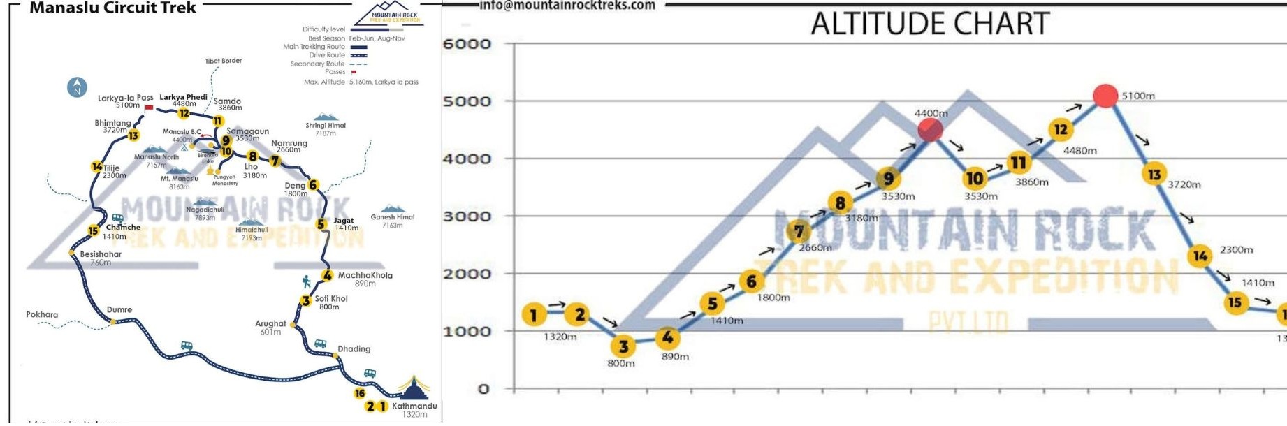
A realistic Manaslu Circuit itinerary for May (14–16 days)
Manaslu Circuit Trek Itinerary and Altitude Map
DAY
ITINERARY
TIME
ALTITUDE
01
Arrive in Kathmandu
30 min drive
1,350m
02
Drive to Soti Khola, continue to Machha Khola
7–8 hrs
869m
03
Machha Khola to Jagat
7–8 hrs
1,410m
04
Jagat to Deng
6–7 hrs
1,860m
05
Deng to Namrung
5–6 hrs
2,630m
06
Namrung to Shyala
5–6 hrs
3,575m
07
Shyala to Samagaon
5–6 hrs
3,520m
08
Samagaon acclimatization (Base Camp or Pungyen Gompa/Birendra Tal)
6–7 hrs
3,520m
09
Samagaon to Samdo
4–5 hrs
3,875m
10
Samdo acclimatization (border viewpoint hike)
~8 hrs
up to 5,030m
11
Samdo to Larkya Phedi (Dharmasala area)
4–5 hrs
4,460m
12
Larkya Phedi to Bimthang via Larkya La
8–9 hrs
3,590m
13
Bimthang to Dharapani or Tilje
~7 hrs
~1,963m
14
Shared jeep to Besisahar + bus to Kathmandu
9–10 hrs
1,350m
15
Depart Kathmandu
~30 min
The Manaslu Circuit is a rugged trek that forms a horseshoe around the 8,163 m Manaslu Mountain. It covers a distance of 180 km, inclusive of low-humidity river valleys in the lower regions and the high glaciation region on the upper reaches. The trek starts with an easy drive from Kathmandu to the upper part of the Budhi Gandaki River. It continues via deep gorges to the terraced hills, where the villages become more influenced by Tibetan culture. It ultimately ends with a descent into the Marsyangdi Valley onto the Annapurna Circuit before returning to Kathmandu.
The majority of Redditors (trekkers) have stated that this trek is more "wild" and less commercial than Annapurna. This is especially true during May. It offers quieter teahouses and opportunities to have larger mountain views, along with more of the feeling of remoteness.
Days 1–2: Kathmandu → Soti Khola → Machha Khola (869 m)
Expect a long, dark, dusty, bumpy ride in either a jeep or a bus. Then you will have an easy-to-moderate level warm-up trek. The trail is usually very wide with suspension bridges along the way and villages beside rivers. However, the added heat and humidity at the beginning of the trek can be intense.
Days 3–4: Machha Khola → Jagat → Deng (1,860 m)
The gorge is more narrow, and the trekking becomes more physically demanding with ups and downs, rocky terrain and walking over many suspension bridges. There are many reports on Reddit that the jungle feel in this section can be a negative experience, as there are often leeches (depending on the time of year) when it rains heavily, so it is recommended that you have quick-dry socks along with paying close attention.
Days 5–7: Deng → Namrung/Shyala → Samagaon (3,520 m)
As your elevation rises, you begin to see how different the valley is and how much the culture of the people living in this area is changing. Along the way, you will see many mani walls, chortens, stone villages, barley fields, and yaks. The views are beginning to be much larger than you had seen in earlier days and will continue to get larger as you make your way to Samagaon, which most hikers believe will be the village they remember most due to the many monasteries, mountain amphitheatre, and relaxed acclimatization pace.
Day 8: Acclimatization in Samagaon
The day usually includes a hike to Pungyen Gompa or along the trail toward Birendra Lake. According to multiple reports on Reddit, the photo opportunities here are extraordinary, with turquoise glacial water, a large Manaslu cliff, and the chance to rest before moving on to much higher elevations.
Days 9–11: Samagaon → Samdo → Larkya Phedi (4,460 m)
The trail from Samagaon to Samdo and Larkya Phedi is northward heading to the Tibetan plateau, leading to another challenging high-altitude area. The settlement in Samdo feels very remote. Some trekkers recommend an acclimatization hike to a ridge above 5000m before the pass in order to gain familiarity with the route and to help reduce the risk on crossing day. Larkya Phedi consists of basic accommodations with no shelter and cold nights.
Day 12: Larkya La Pass → Bimthang (3,590 m)
This is the crux of the trek, beginning with an early, pre-dawn start, followed by a long, tiring hike on loose, windblown slopes leading to the summit, decorated with prayer flags and creating breathtaking panoramic views. Some hikers on Reddit say that early May can still have a snow accumulation and possible icy conditions while making the descent to Bimthang. Bimthang feels much like the "jewel" of the trek, when all is said and done.
Days 13–15: Bimthang → Tilje/Dharapani → Kathmandu
The trip continues with hiking down from Bimthang to either the trailhead or Tilje/Dharapani. The trails go through dense forests of all kinds of trees, primarily rhododendron, before reaching a junction with a road near Dharapani, where you will take a jeep or bus back to Kathmandu through Besisahar. The fare for this part of the journey fluctuates as you pass through the area where Annapurna circuit treks share the same route for a short distance before your trek ends.
Larkya La Pass in May: Snow, Wind, and How Hard It Feels
The Larkya La (around 5,106 m on the Manaslu Circuit) will generally be open in late May, as it usually falls on the last day of spring and the snows of winter are starting to melt. The major drifts of deep snow that block this area are usually gone, and you will not have to walk in deep snow up to your knees for the majority of your ascent. The daytime temperatures at this altitude will typically be below freezing until the sun hits the trail and the snow and/or ice around the summit of Larkya La (for example) softens during that time.
Snow and Trail Conditions
Currently, at higher elevations, the amount of snow has decreased by May. Most trekkers describe the trail primarily as rocky and clear compared to previous months. In addition, there may still be hard, frozen areas located at the higher elevations. This is especially true along the shaded portions of the trail. Therefore, microspikes or crampons are recommended as precautionary equipment, not simply ‘nice’ to have. Many online Reddit discussions reference how weather and snow conditions vary greatly at any of the high passes. With regard to what you might experience, you may have sections of snow along your way. You may also be caught by surprise by unexpected flurries or snowfall.
Wind and Cold
Near the Pass, there are many gusting winds, which will make you feel colder even during early spring. A windy day will have an extremely strong wind chill effect, causing it to technically feel much colder than the temperature shown on the thermometer.
Guides recommend that you start early enough (3-4 am) to get over Larkya La before the winds start blowing stronger. Morning winds are generally just beginning by mid-morning.
Difficulty of the Crossing
Although crossing Larkya La is not a technical climb, it presents some very real challenges. These challenges include high altitude (5100 M), long climb time (8-10 hours), physical endurance, and unsatisfactory oxygen levels in the atmosphere. Altitude sickness will have a profound effect on everyone crossing Larkya La. Even the most fit trekkers will feel out of breath, move slowly, and need many breaks due to the lack of oxygen.
The trail to cross Larkya La is steep, rocky and has ice along with a steep slope, making it slippery. Therefore, it takes a lot of physical energy and mental concentration to cross Larkya La.
Final Reality Check
In the month of May, the Larkya La Pass is a tough but achievable destination for prepared trekkers. You will experience cold wind and possibly some snow and/or ice at the summit, long days of trekking, and altitude-related challenges. However, the conditions for traversing the Larkya pass are far more favourable during May than at either of the winter months or during the monsoon months.
Permits and Guide rules to Follow in Manaslu Circuit Trek, May
Essential permits you must carry in May
You will need to secure at least 4 different permits in order to do the Manaslu Circuit trek in May.
The most important of these permits is known as the Manaslu Restricted Area Permit. This particular permit covers the section of the trek called "Restricted Area" between Jagat and Samagaon. The cost for this permit typically costs around 75 USD for your first 7 days in this "Restricted Area." If you stay longer in the "Restricted Area," then you will have an added daily cost based on how long your itinerary remains within that zone.
In addition to your Manaslu Restricted Area Permit, you will also need the Manaslu Conservation Area Permit as well as the Annapurna Conservation Area Permit because you do exit through the Annapurna region when you begin to head back during the last part of your trek from Manaslu to Base Camp (Annapurna).
You will also be required to pay a local municipality's entry fee, which is typically charged for the Chumnubri area. Therefore, when you combine all of these permits together, many trekkers will be charged close to 250 USD per person (this amount varies based on the duration of your stay on the trek and the agency handling your booking).
Guide and group rules that are strictly enforced
According to the 2026 new laws, one trekkers are eligible to get a permit through a registered trekking agency; yet they are required to hire a guide throughout their trekking journey. Individual/independent trekking is not permitted at all.
Permits can only be obtained through a registered trekking agency, and an unregistered/freelancer guide cannot obtain them. The role of a guide is important not only in the navigation of the route but in obtaining and managing permits, dealing with the procedures with the agency and checking posts on the route.
You are required to carry the permit always since it would be checked at the check posts on the Manaslu Circuit. The police are frequently seen on the trekking routes, and if they see any permit-less trekkers or unsupported trekkers without a guide, you will not be allowed further on the trek.
Application process and on-trial compliance tips
You will need to prepare your valid passport for at least six months' duration, some photos, and insurance that covers helicopter evacuation up to 6000 meters. The official agencies will need your original passport details to issue the restricted permit. Hence, it is better not to delay this part of the preparation. Your guide will have a logbook that needs to be stamped at various checkpoints like Jagat, Philim, Namrung, and Dharapani. It is always better to plan your itinerary realistically and keep to the same route as recorded in the logbook. Some trekkers suggest carrying some extra copies of the permit and keeping a cell phone photo of each page of the permit as well.
How much does the Manaslu Circuit Trek actually cost?
The cost of a Manaslu Circuit Trek, which takes an average of 14 days, ranges between 850 and 2000 USD per person. Budget group tours cost between 850 and 1050 USD, which includes accommodation, permits, a guide, and transport. The cost for a standard package with a porter and meals ranges between 950 and 1250 USD. For a solo private trip with a higher service standard, the cost ranges between 1400 and 1800 USD, while some premium packages, which include everything, cost up to 2000 USD.
Why May changes pricing
Since May is a shoulder season, the restricted area permit costs less, at 75 USD for the first seven days plus an additional 10 USD for every extra day beyond that. However, a smaller group size in May means that you will not save much on the cost, which is a saving per person for a larger group traveling in autumn.
What increases the cost
You may have to shell out an extra 100-200 USD if you have to arrange for a second trekker to meet the minimum requirements. Additionally, private jeeps, extra days of acclimatization, and hiring a porter to carry lighter loads may increase the total. If you are stopping at higher-altitude destinations before Larkya Pass, meals and drinks may cost as much as 25-40 USD per day. The total may even go over 1500 USD when including insurance and other miscellaneous expenses. It’s always better to carry your own snacks to avoid these expenses.
Guide Requirement and Agency Handling Fees
This trek requires a licensed guide. The guide fees generally fall in the range of 25-40 USD per day. Over a period of 12-16 days of trekking, this may prove to be one of the biggest expenses. The total guide fees may come out to be around 300-640 USD. Additionally, some trekkers may have to shell out extra amounts as agency handling fees.
Porter Costs and Load Sharing
The cost of hiring porters is about 20 to 25 USD daily, which translates to about 240 to 400 USD overall. One of the most popular options to deal with the cost of hiring porters is to share one porter between two travelers, which will make the overall cost more manageable, even as you ensure that you have lighter packs for the higher passes.
If you are trekking alone, there may also be extra costs associated with ensuring that there is a minimum group of people, which may increase the overall cost of hiring porters.
Manaslu Circuit Trek May Departures 2027 and 2028
May is the last month of spring prior to the monsoon season, lending itself to great trekking weather and colorful scenery. Departure dates refer to specific starting dates for each trek. On the departure date that you have chosen to begin your trek with us, you can expect to arrive in Kathmandu, meet your guide and other members of the trekking group, attend a briefing session, finalize any last-minute preparations needed for your trek, and depart on your trek. Your entire trek will be organized in advance, ensuring that your trip will run as smoothly as possible with minimal effort on your part to prepare for it.
You will have the following departure dates in May of 2027:
May 3, 6, 9, 11, 14, 17, 20, 23, 25, 29
And May of 2027:
May 3, 6, 9, 11, 14, 17, 20, 23, 25, 29
If you have decided to join this trek in May, please contact us directly and choose any of the previously listed dates as your departure date.
Teahouses in May: Rooms, food, showers, charging, Wi‑Fi
The month of May is considered a shoulder season for the Manaslu trek, which means that there is enough availability of rooms in teahouses, although they may be less busy than they would be in other weeks of the season. Rooms are basically twin rooms or dorms with mattresses and blankets, which are often included in the overall package by the trek operator to ensure that there is no last-minute unavailability of rooms. In villages such as Namrung and Samagaon, which are larger, there may be slightly bigger rooms, although there may be attached bathrooms in some of them. In places such as Dharamshala, there are only a handful of places, which are quite basic.
Food in May
Food is always available in May, and it is usually included in the package three times a day for breakfast, lunch, and dinner. You can expect full meals like dal bhat, noodles, fried rice, momos, eggs, soups, tea, etc., with a few more western dishes being available in places that are better supplied, like Samagaon. As you go higher, the food becomes less available, but the quantity remains large, and warm, and generally, it is best to stick to carb-heavy meals.
Showers in May
Hot showers can be expected at lower- and mid-altitude tea houses, which are usually solar- or gas-heated, and the lower crowds of May can make this easier to find. There will be an extra charge for this, about 5-10 USD, where hot water is available, though at some places, only cold water will be available, or none at all.
Charging
In May, most of the teahouses along the route usually provide charging services, mainly using solar power. With fewer trekkers on the route than in other months, the availability of charging services is usually not a problem. Solar power is best used during the day, so it is recommended that one charges their devices early because the power available at night is usually weak. In addition, the cost of the services varies from USD 1-3 for phones, USD 2-4 for camera batteries, and USD 3-5 for power banks, depending on the location of the teahouse. In villages such as Samdo or Dharmashala, the availability of charging services is usually low, so it is recommended that one carry at least one power bank of high capacity.
WiFi
Some of the teahouses along the route usually provide WiFi services, mainly in the villages at lower altitudes such as Jagat or Samagaon. However, the WiFi services are usually poor and unreliable. At high altitudes, WiFi services are usually unavailable. The cost of WiFi services varies from USD 3 to 5 for each device or each day of use, depending on the location of the teahouse. To access better WiFi services, one can use local SIM cards such as Ncell or Nepal Telecom, which are usually available along the route up to Samagaon. However, the services are usually unavailable near or beyond the Larkya Pass, resulting in long periods of time without connectivity.
What should I pack for the Manaslu Circuit in May?
Clothing
May consists of warm mornings and sunny afternoons, but can become cooler at night and in the upper elevations. A light wicking base layer with a fast-drying short-sleeve hiking shirt can be augmented with a light fleece for early starts. In addition, pack a lightweight down jacket for stopovers and evening use, along with a waterproof/windproof shell for unexpected rain showers and windy ridges. Bring trekking pants, thermal leggings for your higher altitude days, and something comfortable and dry to wear while sleeping.
Footwear
Select a pair of worn-in, supportive boots that provide good ankle support and have a reliable sole that is not slippery. Bring 3-4 pairs of wool or synthetic socks and a blister kit. Also, at elevations above 3000 metres, carry mitts, a hat, and a neck warmer; all of which should be insulated.
Hiking Packs and Equipment
The ideal pack for a day hike should have a capacity of 30-35 liters, as well as a hip belt and rain cover. You will also want a decent-quality duffel bag if this is where your porter will carry all of your gear. You should also pack trekking poles, a headlamp with extra batteries, glasses for protecting your eyes from the sun, sunblock, and a liner for your sleeping bag.
Health and Electric Power
A personal supply of your own medications, first aid kit items, water purification tablets or filters, wet wipes, and a battery-powered charging device with cords will be necessary. You may consider including earplugs for lodging, toilet tissue, and hand sanitizers (many lodges provide these items). You should also keep copies of all of your permits with you.
Water on the Manaslu Circuit: What you’ll Drink daily
On the Manaslu Circuit, plan to consume 3-4 liters a day through tea because the altitude and lodge-dwelling will dehydrate you in hours. The majority of trekkers rely on boiled water sold by teahouses, since it is there whenever you sleep and reduces the risk to the gut compared with untreated sources.
In the lower village, such as Jagat and Deng, taps and lodge water sources are abundant. Further up, particularly past Samagaon and towards the passes, streams and spouts are more frequent but also icy cold and should always be treated. During shoulder months, like May, supplies are plentiful, but you will need enough capacity for a couple of legs between towns and for when kitchens are busy in the afternoons.
When available, bottled boiled water is usually about NPR 200-400 per liter, and it’s the best bang for your buck. A bottle of water could cost between NPR 100 and 500 and is a rare commodity with prices that can only go up the higher you climb. Please bring two 2 wide-mouthed water containers or a hydration bladder. Fill at lodge kitchens, taps, or streams, and treat with tablets, a filter, or UV before drinking.
Manaslu Circuit Trek in May Festivals and Celebrations
Saga Dawa
Significance
Birth, Enlightenment, and Nirvana of Buddha
Key Activity
Raising the Tarboche flagpole, chanting, and "Kora"
Diet
Strictly vegetarian during the festival period
Saga Dawa is the "Festival of Merits." In the Manaslu region, specifically in villages like Samagaun, locals gather to replace old prayer flags with new ones. It is believed that any good deed done during this month is multiplied a thousandfold. Trekkers will see monks performing masked dances and hear the deep resonance of long horns (Dungchen) echoing through the valley.
2028 Date: May 31, 2028
2027 Date: May 20, 2027
Primary Places: Samagaun, Samdo, and Mu Gompa (Tsum Valley).
Buddha Jayanti
Significance
Celebration of Lord Buddha's Life
Key Activity
Carrying holy scriptures through the village
Vibe
Festive, communal, and highly spiritual
While Saga Dawa covers the whole month, Buddha Jayanti is the specific day of the full moon. In the lower Manaslu regions like Philim and Namrung, villagers dress in traditional Tibetan chubas and carry heavy wooden-bound scriptures from the local monasteries on their backs, walking in a procession to bless the upcoming harvest and ensure a "smooth route" for travelers.
2028 Date: May 1, 2028
2027 Date: May 20, 2027 (Overlaps with Saga Dawa)
Primary Places: Philim, Lho, and various monasteries along the trail.
FAQ Manaslu Circuit Trek in May
When should you start your trek in May?
Generally, if you trek during the beginning of May, your trails will be dry, and your weather will typically be more stable with clearer skies during the mornings and therefore superb mountain views under blue skies.
By the end of May, the pre-monsoon effects really start to be experienced with several days of afternoon showers, significant cloud buildup, and softened ground in the lower regions from intermittent rainfall, meaning the landscape continues to be beautiful but can also be unpredictable during the upcoming month of May.
Early May vs mid/late May what typically changes?
In early May, generally, the trails are dry, and the weather is generally stable with clear skies providing great views of the mountains on a clear morning with nothing but blue skies.
When it gets to mid-late May, the area starts to develop into a pre-monsoon environment with increased occurrences of afternoon rain showers, clouds forming in the afternoons, and rain softening the ground on the lower sections of the trails. Therefore, the views of the mountain will still be beautiful, but conditions will be more unpredictable.
Which is the best time of day to hike, and why do early starts matter in May?
The best time of the day to go hiking is early in the morning, before the late morning heat or weather changes in the afternoon.
Generally, morning trail conditions are calmer with clearer skies, no wind, and firmer trail surfaces, which will give you a more secure footing and a much better view of the mountains before the clouds start to obscure them or the mist from the heat of the day develops.
Should I build buffer days for weather and acclimatization in May for the Manalsu Circuit Trek?
You also need to incorporate several buffer days for weather delays and genuine acclimatization.
In the Himalayas, the weather can change quite quickly even in May, and extra days mean you’ll be able to accommodate for sudden changes or get a little more rest if altitude symptoms do appear.
Gradual acclimating can also prevent you from getting altitude sickness, and let’s face it, help you conquer higher passes more easily.
Where are the toughest sections in May along the Manaslu Circuit Route?
The most difficult areas in May are typically above Samagaon and near Larkya La Pass. The climb to the pass is steep and steady, and even in May, it can be cold and windy at high elevations. Beyond the pass, the long downhill to Bhimtang is a steady test of balance and power, with varying terrain types around slide-prone zones that may require adjusting effort on different surfaces if conditions change.
Dipak starts to step up from porter, guide, and trekking leader to the company owner. Sometimes he share his experience with others as well as wrote in local travel news. Most of time he spend his time on mountain and his company.