Kanchenjunga Base Camp Trek is a well-trailed route despite being a journey into the wilderness, as the region bears a mild topography and is easily accessible. Kanchenjunga, meaning Treasures of Snow, stands 28,198ft tall, the third-highest peak in the world. Considered a remote trek through Eastern Nepal, the trail passes restricted areas and takes the periphery of the border to the Indian state of Sikkim.
The trek starts after a flight to Biratnagar and a four-hour drive to Basantpur. The trail climbs through the settlements of the yak herders, Sherpa, and Chhetri villages with a backdrop of the Kanchenjunga massif. Crossing the ridge towards the Tamur River, panoramic views of Makalu and Chamlang appear. The trail crosses the Mewa Khola at Dobhan and follows the TamurKoshi. Dense rhododendron, pine, and oak forests pass along the way.
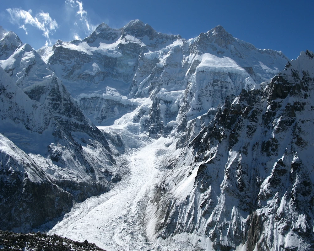
At Ghunsa, a Sherpa village, prayer flags and gompas are plenty. Jannu and other unclimbed peaks can be seen from a monastery nearby. Next, the trail passes through the edge of Kanchenjunga Glacier. After crossing the junction of Lhonak Glacier and the valley, we come to a gorgeous clearing with a magnificent landscape of unspeakable beauty, where we set camps for the day. Lhonak’s exploration continues for some days, including going to Pangpema to view Kanchenjunga’s north face. Then, slowly descending through Tortong, Yamphudim, Khebang, Phakholing, and Tharpu, we reach Bhadrapur, where we take a flight back to Kathmandu.
Eastern Nepal is distinguished by increased diversity on several levels, including ethnic groupings like the Rai and Limbu people, the richness of flora due to the region's higher summer rainfall, and some of the most breathtaking mountain vistas in the Himalayas. We enter a different environment by traveling along the glacial torrent of the Tamur and Ghunsa Rivers which originate on the northwestern face of the Kanchenjunga Himal. Peaks like Pyramid Peak, Jannu, the Twins, and of course, Kanchenjunga (8586m) dominate the landscape, which is eclipsed by an alpine majesty in practically every direction. On the return trip over the Mirgin La Pass, it is not any less dramatic as we traverse the mountain to the south (4500m). This is a difficult journey in a place that hasn't seen much travel lately.
A trek to Kanchenjunga's base camp is in and of itself an epic adventure that never lets up on the thrill. Compared to other treks in the Indian Himalayan range, the journey to Kanchenjunga Base Camp is considerably distinct from the others. Across the borders of Nepal, Tibet, and India, the Kanchenjunga massifs form a large cross (Sikkim). In India, Kangchenjunga was considered the tallest mountain until 1849, when Everest and K2 were discovered.
Geographically speaking, Kangchenjunga ranks third among the world's highest peaks, together with its five large massifs. Since 1988, there has been a significant increase in tourism to these five Himalayan massifs in the Sikkim region. In the beginning, trekking was prohibited in the region to protect its ecosphere. The explorers slowly revealed the hidden lakes, tribal communities, and forested areas home to a wide range of flora and species.
Starting at Yuksom, the exhilarating trip to Kanchenjunga base camp continues to Bakhim, Dzongri, Laxmi Pokhari, Bikhbari Chaurikhang, Rathong Glacier, Bikhbari, and eventually ends at Bakhim. Trekkers will marvel at the breathtaking views of Mt. Khangchendzonga (8,586 m), Mt. Kokthang (6,148 m), Mt. Pandim (6,691 m), and several other peaks in the area throughout the 11-day excursion. A trekker with an adventurous spirit, a desire to discover uncharted territory, and the resolve and physical stamina to meet the rigors of a physically taxing path through one of Nepal's most remote areas may consider undertaking the Kanchenjunga trek. This trek is typically performed for small groups of people searching for custom dates; we offer knowledgeable advice, preparation, and a high degree of professionalism and care on a trek with a great crew. This trek visits both base camps on the north and south side of the mountain.
What to expect at the Kanchenjunga Base Camp trek?
- Learning about the villages and culture of the Limbu people.
- Enjoy the expansive view of the nearby mountains, including Rating, Chandra Peak, Frey Peak (5830 m), Koktang (6,148 m), Kabru Peak (7,412 m), and the Kabru Dome (6600m). ∙ Meet and get to know the residents of isolated villages.
- An unforgettable experience is a trek to the third-highest mountain's base camp. ∙ Visit a Sikkim tea garden, learn about the many tea varieties, and spend some time outside.
- Take a monastery tour to learn more about Sikkim's vibrant culture.
- Abundant wildlife, including black bears, musk deer, snow leopards, and blue sheep ∙ Strolling across Yalung Glacier
The isolated and lengthy Kanchenjunga journey lasts 6–8 hours each day and is a remarkable vacation experience. This trekking area sees very few tourists. Compared to the Everest and Annapurna regions, Kanchenjunga is less populated. A chance to experience a local homestay and the Sherpa, Rai, and Limbus groups' cultures and traditions in a variety of settings is provided by the base camp trek to Kanchenjunga. The Himalayan black bear, musk, leopard, and red pandas can all be seen in the Kanchenjunga region, along with a variety of birds, shy dragons, amphibians, mammals, re-billed blue magpies, and pheasants.
Kanchenjunga, the third-highest mountain in the world at 8,586 meters, is visited by trekkers on the Kanchenjunga Circuit in both the north and south base camps.A decent degree of fitness and previous trekking experience is preferred for this trek because it takes place in a remote location. Nevertheless, despite its isolation, trekkers can visit Ramtang and Oktang Monasteries and acquire insight into the local culture. Along the way, the scenery is diverse and includes rivers, waterfalls, green meadows, birch and pine forests, the Yalung Glacier, and of course, the majestic mountains that line the route.
Regarding the mountains themselves, in addition to the Kanchenjunga peak, there are four additional peaks that are higher than 8,000 meters, with Kanchenjunga West, also known as Yalung Kang, being the most significant (8,505m). Twenty peaks higher than 7,000 meters are also present in this region, the tallest of which are Kambachen (7,903 meters), Janu (7,710 meters), Jongsong (7,483 meters), Kabru (7,353 meters), Tent Peak (7,365 meters), and the Twins (7,350m).
There are also many peaks higher than 6,000 meters. Five significant glacial systems can be found within this remarkable collection of peaks. These include the Zumu, Talung, and Rathong glaciers, which flow into Sikkim, and the Kanchenjunga and Yalung glaciers, which flow into Nepal's great Tamor River.
Is Kanchenjunga Base Camp Trek right for you?
The 220-mile Kanchenjunga trek is a challenging and demanding, necessitating high physical condition for three weeks of continuous walking while carrying a light rucksack. There are a few places around the base camps where it could be required to use short ropes to help move across rocky terrain because the terrain is frequently harsh with rocky roads and some long hills These provide protection and assistance for individuals crossing short rough portions. However, no climbing experience is necessary for the hike.
It is classified as a challenging trekking location in Nepal's Kanchenjunga. This hike is challenging. It's difficult if you have to navigate a variety of mountain passes while enduring challenging ascents and descents. Additionally, the length of time required for this expedition makes it challenging. For more than three weeks, you will be traveling through little towns in the countryside.
It takes a lot of effort to travel to the highest elevation of 5150 meters, which requires crossing multiple mountain passes. To continue, you need a ton of patience and tenacity. Otherwise, it is exhausting to travel across challenging passes, untamed glacier rivers, isolated forests, and mountainous terrains! Before climbing Kanchenjunga, one must first obtain a restricted area trekking permission from the government of Nepal. You can't continue there. You must travel with a licensed, qualified guide.
Although challenging, this walk is not insurmountable. Anything is achievable with a strong sense of purpose and well-thought-out strategies. Success depends on a variety of factors in addition to what you do. You must travel with the proper business that has a qualified crew and guide.
How to prepare for Kanchenjunga Base Camp Trek?
Enhancing aerobic and strength endurance as well as becoming accustomed to carrying a daypack upwards for extended periods of time are all important components of training for Kanchenjunga Base Camp. You should start going on long walks and hiking at least once a week eight to twelve weeks before to your trip (focus on duration more than distances). Build up a 4-6 hour hike or walk with little pauses.
If your neighborhood doesn't have any sizable hills or mountainous terrain, walk hill intervals on a treadmill and stair stepper twice a week. Two times per week of full-body strength training appear to be beneficial for the majority of people. Before undertaking a strenuous physical endeavor like hiking to Kanchenjunga Base Camp, you should always consult your doctor. Before beginning any fitness program, we advise you to consult your doctor.