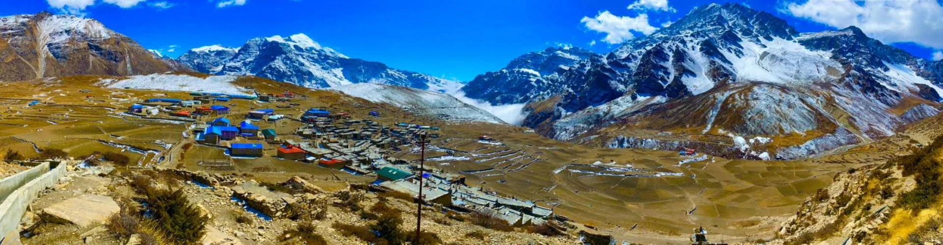
Introduction to The Lost Valleys of Nepal Nar Phu Valley Trek Beauty
The Lost Valley of Nepal is the common nickname for the Nar Phu Valley because it's so remote, with such a distinct Tibetan culture, and because of when the area was first opened to foreign trekkers. This region in the high Himalayas is located north of the more traditional Annapurna Circuit, very near the Tibetan border, and was essentially isolated from the outside world for hundreds of years.
Nar and Phu still feel like another world compared to the more heavily travelled routes of the greater Annapurna region. The trek starts out on a section of the classic Annapurna Circuit, but at Koto, it veers off into an altogether new kind of landscape, one dominated by remote canyons and barren cliffs, secluded monasteries and traditional medieval-type villages.
As Nar Phu has been a restricted area, access for trekkers was and is so limited each year, the pristine quality of the valley and its Tibetan Buddhist culture are largely preserved. Yak grazing pastures, ancient chortens and stupas, barley fields, and traditional prayer walls are what define day-to-day life in Nar Phu. Trekking through Nar Phu really makes you feel as though you're visiting another kingdom lost in the Annapurnas and Manaslu.
Nar Phu Valley Trek Beauty facts
Facts | Details |
Trek Region | Annapurna Region, Nepal |
Famous As | The Lost Valley of Nepal |
Main Villages | Phu Village and Nar Village |
Trek Starting Point | Koto |
Highest Point | Kang La Pass (5,320m) |
Best Beauty Highlights | Deep canyons, cliffs, glaciers, Tibetan villages, monasteries |
Major Mountains Seen | Annapurna II, Gangapurna, Tilicho Peak, Himlung Himal |
Famous Monasteries | Tashi Lhakhang Monastery, Nar Phedi Monastery |
Landscape Type | Dry Himalayan valleys and alpine wilderness |
Local Culture | Tibetan Buddhist and Khampa descendant culture |
Main Livelihood | Yak herding and barley farming |
Famous Trek Route | Annapurna Circuit side trail |
Restricted Area Since | Opened to trekkers in 2002 |
Best Seasons | Spring and Autumn |
Trek Difficulty | Moderate to Challenging |
Why It Is Unique | Remote trails with untouched Himalayan culture and scenery |
Where Is Nar Phu Valley Located and How Do You Reach It From Kathmandu?
Location of Nar Phu Valley, Nepal
Nar Phu Valley is in the northern region of Nepal within the Annapurna Conservation Area in the Manang District. The valley is located adjacent to the Tibetan border, tucked away northeast of the main Annapurna Circuit trek path. This isolated region of the Himalayas comprises the traditional hamlets of Phu Village and Nar Village, nestled between cliff walls, glaciers, and high-altitude landscapes. Due to the remote geography and its status as a Restricted Area, Nar Phu Valley remained off-limits to foreign trekkers until 2002.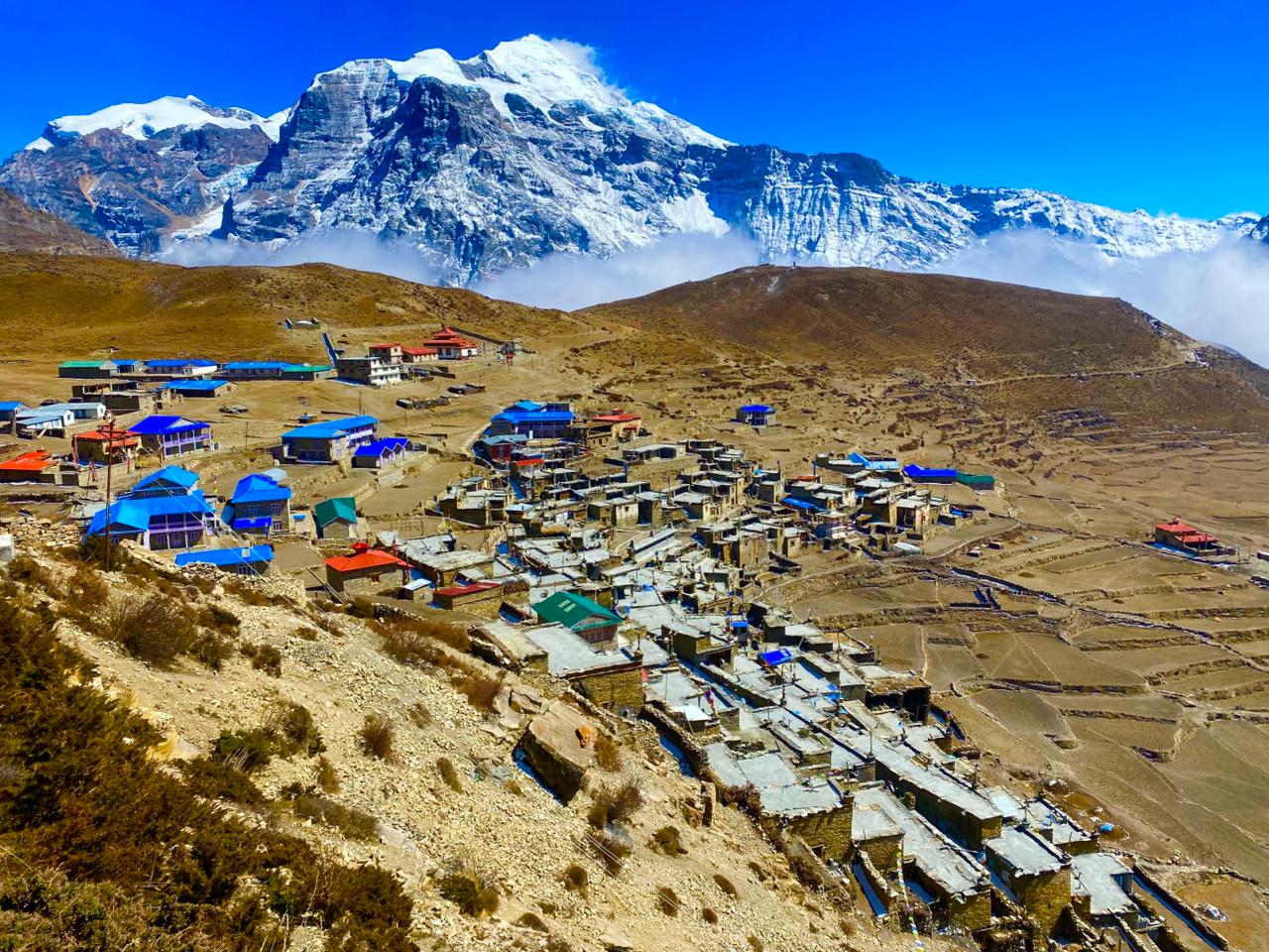
Geographic Coordinates and Elevation
Nar Phu Valley is located at roughly 28.73N, 84.02E latitude and longitude. Phu Village rests at roughly 4,080m above sea level, while Nar Village is at a slightly higher 4,110m elevation. The celebrated Kang La Pass, which connects Nar to the Annapurna Circuit at Ngawal, stands at a formidable 5,320m. Surrounded by peaks such as Himlung Himal, Annapurna II, Gangapurna, and Tilicho Peak, Nar Phu is an imposing destination.
Route of Access From Kathmandu to Nar Phu Valley
A long trek to Nar Phu Valley starts from Kathmandu on a drive up to Chamje via Besisahar and Dharapani. From Dharapani, the trek will continue onward to Koto, where trekkers can begin their exploration of the Nar Phu Restricted Area. Once on the trail, trekkers can stray from the traditional Annapurna Circuit trail and traverse a hidden landscape with suspension bridges, narrow canyons, forests, and isolated Tibetan-style villages. The general route follows Koto to Meta to Phu Village to Nar Village to Kang La Pass and back onto the Annapurna Circuit to Ngawal and Manang.
Mode of Transportation to Reach Nar Phu Valley
Nar Phu Valley can be reached via a drive from Kathmandu to Besisahar (either by tourist bus or a private jeep). Then one must take another jeep ride to Chamje, Dharapani, and finally to Koto, which marks the starting point of the Nar Phu Valley Restricted Area, and is located directly on the main Annapurna Circuit trek path. After one reaches Koto, their travel on the Annapurna Circuit is halted, the trekking begins by walking from Koto to Meta to Phu Village and finally to Nar Village. The majority of trekkers then continue on toward Ngawal/Manang, eventually catching a ride in a jeep down to Besisahar and continuing the drive back to Kathmandu.
How far is Nar Phu Valley from the famous Annapurna Circuit Trek?
Nar Phu Valley is actually just off of the main Annapurna Circuit trek path and is only accessible by walking off of the main trail after Dharapani (and passing through Koto). Nar Phu Valley is merely a day or two's walk (1 - 2 days) away from the typical Annapurna Circuit path, though it will feel world's away due to it being a restricted area, isolated, without other towns, and deep in a side valley. It will also only bring you back to the Annapurna Circuit close to Ngawal and Manang, just after crossing Kang La Pass.
Find Why It's Called The Untouched Beauty and A Hidden Himalayan Kingdom Above 4,000m
- Nar Phu valley is known as untouched beauty due to its remaining off-limits to outsiders until 2002, when it was preserved in its original Himalayan landscapes and traditions.
- Very little development has taken place within the Nar Phu valley, with most villages consisting of old stone houses and old monasteries.
- Village life still continues the same as it did hundreds of years ago; it is located far off in an isolated trans-Himalayan region surrounded by high mountain deserts with arid cliffs and deep gorges above 4000m.
- The two main villages of Nar and Phu maintain unchanged Tibetan-Buddhist traditions.
- The valley has kept its environment clean due to its isolation from main roads and trade routes. Its main economy relies on yak herding and barley farming by its Khampa ancestors.
- Due to the presence of high passes such as Kang La and the terrain, it appears like a hidden Himalayan Kingdom, which is protected by the rugged mountain environment.
- Its isolation above 4000m, coupled with cultural richness, gives it a unique lost world type of appeal.
Which Mountains Can You See During the Nar Phu Valley Trek?
Annapurna I - 8,091 m
10th highest mountain in the world, and it’s the most dangerous mountain to climb. It forms the west face of the Annapurna range.
Where Seen: Kang La Pass; Ngawal and Manang viewpoints. Views are clearer in fine weather after reaching the Annapurna circuit.
Annapurna II - 7,937 m
The eastern anchor of the Annapurna massif and the 2nd highest peak of the mountain range.
Where Seen: Kang La Pass (most extensive panorama); Ngawal village; Manang Valley.
Annapurna III - 7,555 m
A massive pyramid-shaped mountain with a very large south face; a technical climbing peak.
Where Seen: Kang La Pass; Ngawal; Manang.
Annapurna IV - 7,525 m
A slender peak east of Annapurna II and III with a prominent glaciated ridge.
Where Seen: Kang La Pass; Ngawal; Manang Valley.
Gangapurna - 7,455 m
Famous hanging glaciers at its base and a glacial lake.
Where Seen: Kang La Pass; Manang; Tilicho route viewpoints.
Tilicho Peak - 7,135 m
A high altitude peak above Tilicho Lake, considered the most dramatic peak in the Annapurna range.
Where Seen: Kang La Pass; Ngawal; Tilicho Base Camp area (if you decide to detour).
Himlung Himal - 7,126 m
A dominant 7,000-meter peak located in the Damodar Himal range just south of the Nepal-Tibet border.
Where Seen: Meta; Phu Gaon; Nar village. Views in the upper Nar-Phu valley.
Nemjung - 7,140 m
A remotely located, infrequently climbed peak north-east of the Annapurna range.
Where Seen: Phu Gaon; Nar valley ridges.
Ratna Chuli - 7,035 m
A significant 7,000-meter peak near the Damodar Himal region.
Where Seen: Nar valley; Kang La Pass panorama.
Khangsar Kang - 7,485 m
It’s also called Roc Noir, and it is located above the Khangsar valley.
Where Seen: Kang La Pass; Tilicho route viewpoints.
Kang Guru - 6,981 m
The most prominent mountain when you start and end the Nar-Phu trek, and the highest peak in the Larkya sub-range.
Where Seen: Koto to Meta trail; Entrance of Nar-Phu valley; Phu village.
Lamjung Himal - 6,983 m
A snow-covered, hulking mountain belonging to the east face of the Annapurna range.
Where Seen: Lower Annapurna Circuit sections; Ngawal and Manang.
Pisang Peak - 6,091 m
A popular trekking peak above the village of Pisang, having a pyramid-shaped form.
Where Seen: Nar village, Ngawal; Manang Valley.
Chulu East - 6,584 m
A most popular trekking peak in the Chulu range, and it offers amazing views of the Annapurna range.
Where Seen: Ngawal; Manang; Upper Annapurna Circuit viewpoints.
Chulu West - 6,419 m
Twin peaks of Chulu East, part of the Manang Himal ridge, are famous for mountaineering.
Where Seen: Ngawal; Manang Valley.
Chulu Far East - 6,059 m
Although smaller than its counterparts, it’s a striking peak and often very noticeable against the skyline north of Manang.
Where Seen: Ngawal; Manang region.
Khatung Kang - 6,144 m
It’s also known as Thorong Peak and is found near the Thorong La Pass area.
Where Seen: Near Thorong La Pass; High ridges above Manang.
Nilgiri North - 7,061 m
Nilgiri Central - 6,940 m
Nilgiri South - 6,839 m
A beautiful three-peak massif that dominates the skyline over the Kali Gandaki valley.
Where Seen: Thorong La Pass; The Muktinath area after the completion of the Nar Phu route.
Machhapuchhre - 6,997 m
A sacred peak with a distinctly fish-tailed summit; arguably the most recognizable peak in Nepal.
Where Seen: Clearly visible on fine weather days from Manang and the high passes.
Hiunchuli - 6,441 m
This is a very popular mountain that is to the south of Annapurna I in the Annapurna Sanctuary.
Where Seen: Manang and Thorong La viewpoints.
Mardi Himal - 5,587 m
A less imposing but very picturesque peak near Machhapuchhre.
Where Seen: Distantly in clear weather days from high passes.
Gandharba Chuli - 6,248 m
This peak has a reputation as "Fluted Peak" and is identified by its ridged faces.
Where Seen: Kang La Pass panorama.
Bhara Shikhar - 7,647 m
Known for its razor-sharp fang-like ridgeline situated within the Annapurna sanctuary area.
Where Seen: High viewpoints around Manang.
What Rivers, Gorges & Waterfalls Make Nar Phu Valley So Beautiful?
- Marsyangdi River: The largest of the Himalayan rivers flows down the Nar Phu route from Besisahar to Koto. The Marsyangdi cuts a deep gorge through the Annapurna region and has many cliffs, roaring rapids, and narrow sections of the valley; hence, it gives a great visual impression of the entire trek.
- Nar Khola (Naar River): This river system is the main river that comes into the Nar Phu Valley after Koto. The Nar flows through Meta, Nar Phedi, and Nar Village in the Nar Phu Valley while forming narrow sections of canyons, crossing over suspension bridges (with prayer flags), and supplying irrigation to small barley fields at higher elevations in the valley.
- Phu Khola: This river runs through Phu Village. It is located in the walls of a fortress-like valley with the steep cliff walls surrounding the Phu Khola and Phu Village. While cutting the deep gorges and creating dramatic erosion patterns, the Phu River helps in the illusion of Phu as a “hidden kingdom.”
- Chyakhu and Khyang Waterfalls: Occur seasonally along the Meta–Phu trail and are very powerful; they drop from high cliff sides into a rocky riverbed. These waterfalls are especially loud during the spring and immediately after the monsoon, and create sounds and movement in the otherwise dry trans-Himalayan landscape.
- Nar Phu Gorge System: A network of narrow canyons that were created by rivers, glaciers, and runoff is located between Nar and Phu. The water flowing through the gorges has carved a narrow corridor of streams, and almost all of the stream channels are above ground at this point. The gorge also contains many suspension bridge crossings, as well as numerous caves and stunning trekking routes along the cliffs.
- Kang La Glacier-fed Streams: Meltwater streams flowing away from the glaciers at higher altitudes (in the area around Kang La Pass) form the alpine water channel system, which feeds into both the Nar and Marsyangdi systems. These two systems also include large areas of upland yak grazing and seasonal wetlands.
What Suspension Bridges and River Crossings Are Found on the Route?
Classic Suspension Bridges across the Marsyangdi River
At the beginning of the Nar Phu trail, beginning in Kathmandu all the way to Koto, trekkers will be able to cross numerous suspension bridges spanning the Marsyangdi River. These bridges consist of long steel cable span walkways, designed to be traversed by trekkers and mule trains. These bridges are suspended far above the rushing water, flowing at great speeds through the bottom of gorges and are the first tangible encounter with the trekking atmosphere of the Himalayas.
Wooden and Steel Cable Bridges through the Forested Areas
As trekkers move from Koto to Meta, they encounter narrower, modern steel cable suspension bridges made with metal railings and wooden planking that span much smaller tributaries and glacial-fed streams at elevations below the forest line in pine forested areas surrounded by rock canyon walls.
River crossings of Nar Khola and Phu Khola
In the restricted Nar Phu Valley, trekkers must negotiate river crossings at Nar Khola and Phu Khola over traditional rope bridges consisting of long lengths of steel cables and thin wooden planks, decorated with colorful prayer flags tied from one end of the bridge to the other, that swing and sway considerably above the flowing glacial water.
High Altitude Gorge Bridges near Meta-Phu Section
The most impressive and dramatic gorge crossings are in the stretch between Meta and Phu. Here, trekkers cross glacial-fed rivers that have cut deep into the surrounding landscape, leaving them with high, narrow crossings spanning hundreds of feet above narrow gorge floors between sterile cliff walls and the stark, raw terrain of the Himalayas.
Seasonal meltwater streams
Outside of the bridges and fixed crossings, it is also common for trekkers to need to cross smaller seasonal meltwater streams using stepping stones or small plank crossings during the warmer months when the streams have diminished significantly in flow or have become dry for the season.
What Monasteries and Spiritual Sites Are Found in Nar Phu Valley?
Tashi Lhakhang Monastery (Phu village)
- Location: Phu village, the eastern part of the Nar Phu valley
- Culture: Tibetan Buddhist (Nyingma)
- Altitude: approx. 4,000m+
- Importance: One of the oldest monastic structures of the region, associated with early Himalayan Buddhism
- Festivities: Lhosar (Tibetan New Year), masked dances, and prayer rituals locally
Tashi Lhakhang monastery is the focal spiritual center of Phu village. Positioned high above the settlement, it provides panoramic views of the cliffs around Phu, which are structured like fortress walls. The Monastery is over 700 years old, and it's associated with the traditions of Guru Rinpoche.
There is a clear emphasis on the Tibetan roots, as it has monks and villagers who say prayers every day in order to maintain their life and wealth in this remote valley in high altitudes.
Things to see and do here:
- Hike to Tashi Lhakhang Monastery for stunning sunrise or sunset views over Phu valley
- Observe prayers and butter lamps being offered by the monks
- Remember to maintain local customs by walking around the Monastery clockwise
Nar Phedi Monastery
- Location: between Koto and Nar Village (lower Nar valley)
- Culture: Tibetan Buddhist Monastery with monks in residence
- Altitude: approx. 2,960m
- Importance: Spiritual entry to the Nar Phu restricted region
- Festivities: Local prayers and Buddhist rituals during the festive season
Nar Phedi Monastery is a riverside, tranquil and important spiritual spot while travelling to the upper Nar Phu valley. Its unique structure offers trekkers the opportunity to stay overnight as monks, and in charge here are resident nuns.
The cliffs on both sides of the river, while traveling to this Monastery, will provide an impression of being transferred from the Annapurna circuit to the remote valley of Nar Phu.
Things to see and do here:
- Stay in the monk guest rooms within the Monastery.
- Experience their evening prayer with singing and chanting.
- Witness a spiritual atmosphere while exploring simple, modest monastic life.
Yul Gompa (Phu upper monastic site)
- Location: Above the ridge overlooking Phu village
- Culture: Ancient Tibetan Buddhist heritage
- Altitude: approx. 4,100m+
- Importance: The monastery that acts as a guardian of Phu village
- Festivities: Local religious rituals during Lhosar and harvest festivals
Yul Gompa, the monastic site above the village of Phu, stands on a higher ground watching over the entire valley. This represents an ancient type of defense monasteries common in the high Himalayas, where religion and geography merge into one.
Things to see and do here:
- Take a hike to Yul Gompa to witness the whole valley on foot.
- Take a look at Mani's walls and chortens spread in its vicinity.
- Experience and be mindful of the ancient village's defense.
Nar village monastic complex (Small gompas)
- Location: Nar village plateau
- Culture: Tibetan Buddhist with strong Khampa traits
- Altitude: approx. 4,100m+
- Importance: A cluster of small monastic sites spread all over the settlement.
- Festivities: Mask dances, Lhosar and religious functions
The village of Nar does not have any huge monastery, but rather a variety of small monasteries all over the Nar plateau. Monasteries in Nar have been integrated within the daily routines of people and signify the deep connection of religion and human existence in high altitudes.
Things to see and do here:
- Hike around within Nar village while observing the prayer wheels inside them.
- Participate in daily prayer rituals and religious ceremonies held by monks/villagers.
- Explore outside the village, in search of Mani walls and sacred chortens.
Who Are the Inhabitants of Nar Phu Valley and Where Do They Come From?
Khampa Warrior Trader Communities (Tibetan Frontier Origins)
Category | Details |
Origin | Eastern Tibetan plateau (Kham region) |
Identity Formation | Migrant warrior–trader groups from historic Tibetan borderlands |
Why They Are Here | Settlement through the old trans-Himalayan trade routes and refugee migration into the Manang highlands |
Culture Base | Tibetan Buddhism blended with pre-Buddhist Bon influences |
Traditional Role | Horse trading, caravan movement, salt–wool–barley trade across the Tibet–Nepal routes |
Population Role | Historical influence; not a dominant population, but culturally important |
The Khampa people who inhabited Nar Phu Valley migrated here from eastern Tibet a very long time ago. They travelled over high mountain passes and then lived in settlements such as Nar and Phu, attracted both by trade and difficult political circumstances back in their home territory. Their traditional ways of living gradually merged with the lifestyle of the indigenous mountain dwellers, and in time, their daily practices, customs, and traditions were transformed.
Narpa Community (Indigenous Nar Village Highlanders)
Category | Details |
Origin | Tibetan-descendant highland settlers in the Manang region |
Why They Exist Here | Long-term settlement in extreme high-altitude environment above 4,000m |
Cultural Foundation | Strong Tibetan Buddhist system with monastery-centered life |
Livelihood Adaptation | Barley farming, yak herding, and seasonal migration to lower valleys |
Population Estimate | Very small (a few hundred in total valley system) |
Identity Shape | Survival-based culture shaped by isolation and harsh terrain |
The Narpa people who reside in Nar village have lived there for generations in a high and cold environment. The arrival of the Narpa at the Nar village was no coincidence, and the Narpa have existed and survived in the hostile mountain environment for quite a long time. Their way of life is inextricably connected to Buddhist monasteries, agricultural cycles, and community aid.
Phupa Community (Phu Village Mountain Fortress Settlers)
Category | Details |
Origin | Tibetan-influenced ancestral highland settlers |
Settlement Reason | Defensive isolation and survival in Phu’s fortress-like valley geography |
Cultural System | Strong ritual Buddhism, monastery-driven social structure |
Economic Base | Yak herding, limited barley farming, trade with the lower valleys |
Population Size | Extremely small and isolated community |
Settlement Style | Stone fortress villages built against cliffs |
The Phupa people who inhabit the Phu village reside in a highly secluded and isolated valley protected by great cliffs. They adapted to their mountain environment and created a peaceful and strong way of living intertwined with religion, nature, and survival. All aspects of life revolve around the mountains that surround the valley.
Ethnic Tibetan-Influenced Highland Population (Overall Origin Explanation)
Category | Details |
Ethnic Root | Tibetan-influenced Himalayan settlers with mixed trans-Himalayan ancestry |
Why They Are Here | Centuries of migration from the Tibetan plateau + adaptation to the Manang highlands |
Cultural Core | Tibetan Buddhism, mani walls, chortens, monastery-based life |
Historical Context | Ancient trade route settlements between Nepal and Tibet |
Population Scale | Combined valley population remains under ~1,000 |
Identity Formation | Isolation + trade route history + high-altitude survival culture |
The inhabitants of Nar Phu Valley ultimately originated from Tibetan migrations and ancient trade networks, and settled there hundreds of years ago to develop their lives over the extreme mountainous terrain, eventually establishing villages such as Nar and Phu, where life and culture have since been influenced by their mountainous isolation.
What Are the Most Beautiful Villages on the Nar Phu Trek Route?
Koto village marks the beginning of the Nar Phu Valley trek, situated on the Annapurna Circuit just off its route. This is the point from where the mainstream trek routes will begin to surrender to the quiet serenity of the Himalayan wilderness; it's the last point near the Marsyangdi River with few signs of life other than the tea-houses and inhabitants of the tea-houses catering for trekking activities in the region. Bordered by lush pine forests and high cliffs, this remote village possesses an aura of awe, instilling a profound sense of entering into a realm of the deities dwelling in the mountains.
- Tea Houses: basic accommodation provided for trekkers going to Nar Phu
- People: a mix of Gurungs and Tibetans
- Culture: predominance of Buddhist beliefs; prayer flags will flutter around, and locals will perform several religious rituals
- Food: readily available dal bhat, noodles, tea, and basic trekking cuisine
- Electricity: available at lodges (mix of solar-grid)
- Animals: Mules and Yaks are used for transport
Meta Village
Situated in the high-altitude Nar Phu restricted region, the sparse, rock-face and desolate landscape surrounding Meta gives one the feeling of having been teleported to the rooftop of the world. It is a transition point, just before the Tibetan terrain unfolds at the start of the valley. The remote village is utterly quiet and intertwined with the lives of nomadic yak-herders.
- Tea Houses: a few simple lodgings that remain occupied primarily during the trekking season
- People: high-altitude dwelling Tibetans
- Culture: heavily devoted to Buddhism and marked by prayer flags
- Food: Tsampa, potatoes, noodles, butter tea
- Electricity: limited; often, the solar system serves as a power supply for houses
- Animals: Yaks, sheep, etc.
Phu Village
Arguably, the most iconic village within Nar Phu valley, Phu village, appears like a medieval fortress carved into and above desolate cliff sides. Phu is the epitome of Tibetan culture found within this valley and a testament to how deeply rooted these customs have become through prolonged periods of intense isolation. The village, situated at over 4,000 meters, offers the feel of a lost kingdom that has not moved on from its past.
- Tea houses: Small, local homestays and a few basic trekking inns
- People: Phupa community (settlers whose origins lie in Tibet)
- Culture: deeply entrenched in Tibetan Buddhism, with several monasteries and stupas
- Food: A simple diet consisting of barley-based meals, soups, and butter tea
- Electricity: Very minimal, with predominantly solar systems powering lights and some appliances
- Animals: High-altitude residents include yaks, goats, and sheep
Nar Village
Nar Village is a high-altitude hamlet nestled on an expansive plain with sweeping views of surrounding peaks. While slightly more exposed and perhaps a bit more connected than Phu, Nar also holds a distinct air of remoteness, with Buddhism playing a central role in the lives of the inhabitants, who also practice seasonal farming.
- Tea houses: Basic structures that can accommodate trekkers who are on the trail to Kang La Pass
- People: Narpa community, a high-altitude people of Tibetan origin
- Culture: A village focused on a monastery and the prayer ceremonies that take place annually at the settlement
- Food: Dal bhat, tsampa, and porridge made of barley and tea are commonly available
- Electricity: Solar power is limited, but available
- Animals: Yaks and horses are used for herding and for travelling on the slopes
Ngawal Village (Exit Point via Kang La Pass)
Ngawal is a picturesque village found on the Annapurna Circuit side of Kang La Pass. In contrast to Nar and Phu, Ngawal is far more developed and boasts more accommodation options alongside stunning panoramic views of the mountains. It embodies the traditional Himalayan lifestyle but also bears the influence of the influx of trekking tourism.
- Tea houses: Lodges and guesthouses offering excellent accommodation
- People: The people here are of mixed Gurung and Tibetan heritage
- Culture: Home to monasteries, prayer wheels, and annual prayer festivals
- Food: Village serves anything from Nepalese dishes to Western trekking meals.
- Electricity: Has a steady flow of electricity and also backup using solar energy.
- Animals: Yaks and mules can be seen roaming the fields and hillsides.
Chyakhu Village
Chyakhu is the smallest and perhaps the most historically important of Nar Phu's transient villages. It lies in the lower part of the Nar section and was traditionally inhabited by Nar villagers during the winter months, when the upper villages would be inhospitable for survival. Only 3-5 stone houses remain today, and as it is the headquarters of Narpa Bhumi Rural Municipality, the village remains quiet but is also a significant political entity within the Himalayas.
- Houses: Around 3-5 stone dwellings exist here
- People: Narpa, who inhabit this village during the cold months of the year
- Culture: The culture here reflects the strong Narpa Buddhist traditions
- Tradition: It was previously a winter residence for villagers to engage in survival farming.
- Food: Simple food that includes barley, potatoes, and tsampa
- Electricity: Sparse, with solar systems in place
- Animals: Yaks and goats graze here during seasonal occupation
Kyang Village
Kyang is the historically important farming village that served the needs of the Phu villagers, sitting on flatter, more fertile grounds than its surrounding barren cliff homes. Used seasonally for cultivation during the warmer months of the year, the village has only begun to provide a couple of basic trekking lodges over the recent years and has thus become a calm stop between Nar Phu and the Annapurna Circuit.
- Houses: The village is mostly made of farm dwellings and some newly built lodges
- People: Mostly Phu villagers who utilize the land seasonally to farm and graze their livestock.
- Culture: Traditional Buddhist practices are maintained through farming techniques.
- Tradition: Traditionally, a site for farming and livestock grazing.
- Food: Food available in the lodge varies from barley-based meals to vegetables grown on site.
- Electricity: Solar-powered and very limited in nature.
- Animals: Yaks, sheep, and other grazing animals are found here throughout the farming season.
What Happens at Kang La Pass and Why Is It the Most Beautiful Viewpoint?
Detail | Information |
Name | Kang La Pass |
Elevation | ~5,320 meters |
Location | Between Nar Phu Valley and Ngawal (Annapurna Circuit) |
Region | Manang District, Nepal |
Main Purpose | High mountain crossing connecting the hidden Nar Phu to the Annapurna Circuit |
Landscape Type | Snow ridges, glaciers, alpine desert, and Himalayan viewpoints |
Trekkers must overcome successful elevation changes as they traverse the highest and most breathtaking mountain passes that connect through the Nar Phu Valley Trek. The long climb to the crossing provides a variety of terrains, including rocky trails, frozen tundra, and thin air. However, once trekkers reach the top of the pass, the hard work will be worth it as they will see spectacular views of one of the highest mountains in Nepal. Trekkers will experience a cultural and natural diversity when arriving at the top of the pass. By travelling between the two different geographic locations, the remote Nar Phu Valley and the well-developed Annapurna Circuit region.
Finally, when trekkers arrive at the top, they will find themselves surrounded by quietness, prayer flags flapping in the wind, and thousands of miles of mountain ranges in all directions. The ambiance at the top is raw and unrefined, with glaciers, snowfields, and deep valleys far below. As trekkers descend to Ngawal and Manang, they will gradually see a change in the landscape from a desolate, high-altitude barren desert to a lush, verdant alpine ecosystem. As a result, trekkers will feel as though they have taken a visual journey through multiple ecosystems in the Himalayas within a relatively short period of time.
What Kang La Pass Shows You
Experience | Description |
Himalayan Panorama | Wide 360° views of the Annapurna and Manang ranges |
Hidden Valley View | Full aerial view of Nar Phu Valley behind you |
Snow Landscapes | Seasonal snowfields and icy ridges at high altitude |
Glacier Systems | Distant glaciers feed valleys and rivers |
Desert Mountains | Dry Tibetan-style trans-Himalayan terrain |
Spiritual Elements | Prayer flags and cairns marking the pass summit |
Valley Transition | Sudden change from Nar Phu wilderness to the greener Annapurna side |
What Religious Practices and Rituals Are Followed in Nar and Phu Villages?
Daily Buddhist Prayer and Ritual Offerings
The villagers in Nar and Phu begin their days by offering their prayers, chanting mantras, and lighting butter lamps at home shrines or in their monasteries, which serve to bless their families and bring good fortune and peace upon them. Prayer flags are erected and hung on their rooftops and across mountain passes to allow prayers and positive energies to disperse along the wind.
Monastery Worship and Lama-Led Ceremonies
The lamas of Nar and Phu provide guidance and counsel the villagers as they attend the spiritual, religious and social events that take place at monasteries in their community. The following are some significant monasteries in the area:
Tashi Lhakhang Monastery: This monastery plays a vital role in spiritual guidance and is also known for its links with Tibetan Buddhism.
Nar Phedi Monastery: This monastery offers a warm welcome and offers daily spiritual provisions for trekkers and pilgrims.
Monks here perform blessings and chant mantras inside the monastery or through sermons.
Rituals for Birth, Marriage, and Death
Life events in Phu and Nar villages follow the Buddhist rituals led by lamas.
Birth celebration: When a new child is born, the family will invite the lamas to provide blessings to the baby and pray for a long, healthy life.
Marriage celebration: For a traditional wedding in Nar or Phu, the ceremony is blessed by lamas in the monasteries with offerings to provide support, as well as fed and co-celebrated with the communities.
Death celebration: After a person passes away, there are specific prayers that are said to help guide the spirit on its spiritual journey. On occasion, there are sky burials for high lamas in which the body is left in the sky to be consumed by the birds in respect for the body being impermanent.
Sacred Structures and Pilgrimage Practices
There are many different religious structures throughout the valley that are used for daily spiritual practices.
Some common religious structures include chortens (which are monuments that keep the village safe and remind the villagers of enlightenment), mani walls (which are massive stone walls carved with the sacred mantra Om Mani Padme Hum), and prayer wheels (which are turned by the villagers for the accumulation of merit).
These structures are located along the village paths and on the trekking trails, and people often walk clockwise around the structures as an extension of their spiritual practices. Every year, the villagers of Nar and Phu celebrate Losar, the New Year's festival. Losar is the key center for the gatherings of the community as the villagers clean their houses, worship at the monasteries to gain good luck, cook food, and dance.
Festival Celebrations and Community Rituals
During the time of festivals, the community as a whole in Nar and Phu. There is one very important one of these:
Losar
Villagers clean and purify their homes and visit the monasteries to receive blessings, eat food, and perform rituals and dance to welcome the New Year and bring forth spiritual protection for the year ahead.
There are other festivals of this sort, depending on the agricultural and monastic calendar, to mark harvest time, and also rituals and ceremonies to bring about spiritual protection.
Ancient Tibetan Buddhist Traditions
The local culture of Nar and Phu is heavily rooted in the traditions from the ancient Tibetan Buddhist teachings, which were passed on by a group of settlers from Tibet a couple of hundred years ago. The locals believe in and practice teachings from two main schools of Tibetan Buddhism, Kagyu and Nyingma.
These schools believe in meditation, compassion, and spiritual guidance. They also often incorporate the older Himalayan practices, with Buddhist ideology, creating a spiritual culture that has not been altered over the years because of the remote location.
How to Trek to Nar Phu Valley and Experience Its Beauty?
Join a group trek
Group treks are one of the most common options to explore the valley. In a group trek, the trekking agency organizes the entire trip, including permissions, guide, accommodation, and travel.
Pros
- Lower expenses since all the members will share the cost.
- Easy permission processing and accommodation arrangement.
- Can meet other travelers.
Best for
- Beginners for trekking in Nepal.
- Travelers who prefer organized tours.
Trek solo with a licensed guide
Many travelers prefer traveling on their own with a guide. For Nar Phu Valley, a licensed guide is mandatory even if you're traveling alone, as Nar Phu Valley is a restricted region.
Pros
- Flexible itinerary.
- Good interaction with locals.
- Safe traveling, even though you are traveling alone.
Mandatory to have
Private trek with friends or family
Another common option is traveling as a private group with your friends or family members.
Pro
- Private itinerary for your group.
- Private luxury and comfort.
- Good for photography lovers and culture seekers.
Extended adventure treks
Most trekkers combine their trip to Nar Phu Valley with other famous routes. Here are a few popular options for a longer trip:
- Cross over the Kang La Pass (5,320 m) and arrive at Ngawal.
- Continue the Annapurna Circuit.
- Cross the Thorong La Pass (5,416 m).
- You will encounter breathtaking Himalayan terrains on these treks.
Permit required to enter Nar Phu Valley
Before the actual trek, you must secure some permits to explore the restricted valley:
- Restricted Area Permit (RAP) for Nar & Phu villages.
- Annapurna Conservation Area Permit (ACAP).
- TIMS Card (Trekking Information Management System).
- The trekking permits help control and regulate tourism so that this isolated valley will preserve its rich culture for future generations.
Standard route to Nar Phu Valley
Most people use the route below:
- Kathmandu -> Besisahar -> Koto -> Meta -> Phu Village -> Nar Village -> Kang La Pass -> Ngawal -> Manang
The trail takes you through beautiful forests, narrow gorges, ancient Tibetan-style settlements, majestic Himalayan peaks, and many high passes.