Ramdung peak climbing

Trip Overview
  • Duration 21 Days
  • Difficulty Level Strenuous or Grade C (***)
  • DestinationNepal
  • Meals & AccommodationBreakfast, Lunch, Dinner
  • Trip Start & EndKathmandu to Kathmandu
  • Trip TypeClimbing and tTrekking
  • Major AttractionRamdug peak, Namche Bazzar
  • Maximum Altitude5755 Meters
  • Best TimeSpring and Autumn

Highlights

  • Observing their way of life, culture, and customs at more significant elevations.
  • The Tibetan Himalayas, Dorje Lakpa, Chobabhamre, and Gaurishanker Himal may all be seen from the accommodation.
  • Climbing to a height of 5755 meters to cross the Tashi Lapcha Pass (18876 ft)
  • Beautiful views from Ramdung Peak's summit
  • This hiking journey starts in the shadow of the beautiful Himalayas and circles several adventuresome Ramdung Peak Climbing Ramdung Peak Rhododendron Forest (Nepal's national flower)
  • The trek's highest and best point is 5,925 meters (Ramdung Peak).
  • Discover the lifestyle, culture, festivals, mountain views, and people of the Sherpa people.
  • Buddhist doctrine
  • Trekking involves mainly lodges and some camping.
  •  The Tibetan Himalayan vistas, the Dorje Lakpa, the Chobabhamre, and the Gaurishanker massif in the Himalayas.Attractions before concluding a settlement.

Ramdung Peak is 5,930 meters south of Tashi Lapcha along the Rolwaling valley and Khumbu border. In the Rolwaling Himalaya, Ramdung Peak is a well-liked hiking peak. Ramdung peak climbing, often referred to as an expedition, provides panoramic views of the Himalayas, including those of Gaurishanker, Dorje Lakpa, Chobabhamre, and the Tibetan Himalayas. The upper Rolwaling area, south of Na, is home to Ramdung Peak, 5925m. Ramdung Peak is one of several peaks around Yalung La that may be climbed to reach upper Rolwaling via Khare Khola. After Bill Murray scaled Ramdung Peak in 1952, adventurers got more familiar with the sport. 

One of the well-known hiking peaks in the Rolwaling area is Ramdung Peak, which offers breathtaking views of the Gaurishanker, Dorje Lakpa, and Chobabhamre mountains. There are other "Yalung Ri" peaks that are nearby and are pleasant and straightforward to climb, stretching from the Yalung La base camp pass to the Yalung Bhanjyang and Ramdung high camps.

The higher Rolwaling may be reached from the south by traveling through the Khare Khola climbing trials at Ramdung Peak. First, ascend to the Ramdung peak, which is complicated to get but is lower in elevation than Parchamo Peak. Two high camps are involved, as is the northeast face trail.

The Rolwaling Valley is the starting point of this challenging trip. Ramdung Peak is situated in the remote Rolwaling Valley, south of the Khumbu-bordering Tashi Lapcha Pass. This summit is seldom scaled, making it less crowded and ideal for hikers who want to walk in a tranquil environment. You will climb the Ramdung peak first, then go spectacularly to the top of Pharchamo.

Despite its height, this peak requires high camps before summiting and is challenging to climb. You will pass through tiny towns, through riverbanks, over wide meadows, and into impenetrable forests. It will be difficult as you climb towards Pharchamo Peak over the Tashi Lapcha La Pass through the glacier moraine. You will be able to witness panoramic views of several peaks, including the formidable Mt. Everest (8,848 m), Mt. Cho Oyu (8,201 m), Mt. Nuptse (7,861 m), Mt. Gaurishankar (7,134 m), and Mt. Ama Dablam (6,856 m). On this walk, you will also encounter stunning rivers and glaciers. Additionally, you will get a taste of the regional residents' way of life, culture, and traditions.

Our Success Trips

We summited the summit and traveled to Nepal with thousands of people. Still, our true victory is to get your destination that brings us to the top with our complete service of trekking, mountaineering, and adventure tours.

Know before you book

Itinerary

Day to Day Info

See All InfoHide All Info

Drive from Kathmandu (1350m.) to Dolakha (1660m.) via Lamosangu (750m.) and Charikot (1980m.) by bus Rest and relax at the camp.

  • Camp
  • Breakfast, Lunch, Dinner
  • 7-8 Hours
  • 1980 Meters

Today, from Dolakha, we trek along the west bank of the Tama Koshi and reach Chetchet, where we enjoy a view of an attractive waterfall. After that, we continue moving downward for an hour or more, and we again climb to the village of Simigaon. Then we make a gentle walk up to the lodge. From this village, we could see Mt.Gaurishanker more clearly.

  • Camp
  • Breakfast, Lunch, Dinner
  • 7 hours
  • 2020 Meters

On the way from Simi Gaun, you come across the Sherpa villages. The ascending trek is rich in diverse varieties of plants and Rhododendron trees. Following the uphill hike, you will now come across ascending and descending paths while enjoying the picturesque beauty of the place. If it happens to be a season, you will witness the Yak Naka; a temporary Yak shed especially for the preparation of cheese and butter.

  • Camp
  • Breakfast, Lunch, Dinner
  • 8 Hours
  • 3976 Meters

From Daldung La, the trek now goes up through different varieties of plants and Rhododendron trees. Next, you trek over the suspension bridges over the deep gorges in a few places making the walk even more enchanting. You finally reach Bedding which is a big Sherpa village.

  • Camp
  • Breakfast, Lunch, Dinner
  • 8 Hours
  • 3690 Meters

We have a rest day today for acclimatization and have panoramic views of mountains like Mt. Gauri Shanker, and Tibetan mountains on the Tibetan border.

  • Camp
  • Breakfast, Lunch, Dinner
  • free Day
  • 3690 Meters

On the way to Na from Bedding, we will see terrain full of the extraordinary scenery of the surrounding high landscapes and the snow-capped peaks. First, we must stroll to accustom ourselves to Na Gaun. From this village, we can view the beautiful summit of Chobutse, 6,689m rises above the Tsho Rolpa  Lake and Trakarding glaciers.

  • Camp
  • Breakfast, Lunch, Dinner
  • 7-8 Hours
  • 4180 Meters

Today, after a long trek you may have a full day's rest at your camp. In the daytime, you can travel around the local areas. At night you will be entertained by a dance party in the Camp with Nepalese folk songs. Rest and relax at the camp.

  • Camp
  • Breakfast, Lunch, Dinner
  • 7-8 Hours
  • 4180 Meters

From Na, the trek goes up high glacier walk with the land enhanced with white ice all over with crampons and ice sacks. You will be staying overnight in the Yalung Glacier high camp.

  • Camp
  • Breakfast, Lunch, Dinner
  • 8 Hours
  • 4750 Meters

You keep ascending until you reach Yalung Danda, and then you trek a steep incline to the Base Camp path. The way you pass through is by the rocky glacier. You can observe an assortment of views of mountains like Gauri Shanker, Menlung, Yalung, and the mountains of Tibet.

  • Camp
  • Breakfast, Lunch, Dinner
  • 8 Hours
  • 5150 Meters

Early morning climb the Ramdung peak 5,930m with your climbing guide, from the peak you can have scenic views of Gauri Shankar, Menlung, Yalung, Pigphero go sharp peak, Number Himal, Yalung peak and the mountains of Tibet. After summiting the peak back to Yalung base camp.

  • Camp
  • Breakfast, Lunch, Dinner
  • 8 Hours
  • 4750 Meters

Today, we descend back to Na; you will be able to get pleasure from the scenic beauty of the environment.

  • Camp
  • Breakfast, Lunch, Dinner
  • 8 Hour
  • 4750 Meters

After trekking at a high altitude, you will have a rest day today. You will be preparing for the trek to Tso Rolpa Lakeside as an optional visit. 

  • Camp
  • Breakfast, Lunch, Dinner
  • 7 Hours
  • 4750 Meters

You will be trekking through the flat and progressively up the path. You will be able to observe the beautiful natural lake filled with the chilling water of the glaciers.

  • Camp
  • Breakfast, Lunch, Dinner
  • 8 Hours
  • 4540 Meters

Early morning you will hike through the glaciers throughout the day and will be able to experience the new captivating beauties that would add extra dimensions to your trial.

  • Camp
  • Breakfast, Lunch, Dinner
  • 8 Hours
  • 4800 Meters

The trail will still be moving up through some rock climbing and a steady walk on the glacier. You will camp at Tashi Lapcha Pedi Camp today.

  • Camp
  • Breakfast, Lunch, Dinner
  • 7 Hours
  • 5755 Meters

You will climb up the Tashi Lapcha Pedi and cross the Tashi Lapcha Pass through Tashi Cape. The completely will be entirely over the snow straight up and then steep down towards Tashi Cape.

  • Camp
  • Breakfast, Lunch, Dinner
  • 7 Hours

Today you will be experiencing a bit of easy glacier walking. The trail descends towards Thyomgbo.

  • Camp
  • Breakfast, Lunch, Dinner
  • 7 Hours
  • 4350 Meters

Early morning you will ascend to Thame. This trail steadily descends and you will have an added experience of a more natural path and will be able to enjoy the natural beauty of the environment.

  • Camp
  • Breakfast, Lunch, Dinner
  • 8 Hours
  • 3820 Meters

From Pheriche, we take a slightly different route to Orsho, then move to Pangboche village. Here we can see the oldest monastery in the region, which contains what is said to be the scalp and bones of a 'Yeti' or the abominable snowman. Leave mountains behind us, and our descent takes us through Tengboche Monastery at the elevation of 3860 meters before continuing back to the town of Namche Bazaar at 3441meters. We arrive back at Namche Bazaar in the afternoon.

  • Camp
  • Breakfast, Lunch, Dinner
  • 5.30 hours
  • 3441 Meters

After having our Breakfast, go back over the main track down to Dudh Koshi retracing to Phakding. Following the trail, we reach Lukla scaling different Sherpa villages and crossing a suspension bridge above Thado Kosh. For about 45 minutes, we climb to accomplish the entire trek, and we reconfirm flight tickets and see off to local porters.

  • Camp
  • Breakfast, Lunch, Dinner
  • 6 hours
  • 2804 Meters

After traveling for 35 minutes, we fly back to Kathmandu

  • ....
  • Breakfast
  • 35 Minutes
  • 1345 Meters

We are pleased to offer the flexibility of tailoring your journey to your desired duration and places, whether extended or shortened, as our proficient team of locals-cum-guides, porters, and accompanying staff have an in-depth understanding of every location traveled.

customize my trip

Cost Details

Includes

  • Transportation to and from Kathmandu by road as per itinerary ( Singati bazaar early season and some time can go Dovan)
  • 3-time meals per day during the trek (Breakfast, lunch, and dinner) including the coffee and tea cook by a professional camping cook.
  • Accommodation provided tents
  • Dining tent, toilette tent and kitchen tent
  • Highly experienced Government training licensed holder guide and necessary porters during the trek
  • Cook and climbing Sherpa
  • Government / Local taxes, Tourist service charge, guide/cook, Sherpa porter insurance and salary, general equipment
  • Gauri Shankar Trekking permit,  national park fees, TIMS permits, and Ramdung peak climbing permits
  • Air tickets from Lukla to Kathmandu
  • Climbing equipment Rope, snow Bar, Ice Hammer, and rock piton required for the peak and the pass
  • Nepali staff wages who back from Lukla to Jiri and transportation to Kathmandu

Excludes

  • Kathmandu hotel
  • Lunch and dinner while in Kathmandu
  • Hard and soft table drinks such as Coke, Fanta, etc. during the trekking.
  • Personal insurance which is covering Rescue operation charge.
  • Tips for guide and porters.

Essential Info

The Route for Climbing Ramdung Peak

Ramdung Peak Climbing starts with the trip from Charikot to Singita through Dolakha, which goes to the fringe of the Gaurishankar Conservation Area. The ascent doesn't start until you reach Daldung La in the second portion of the second day (2,850m).
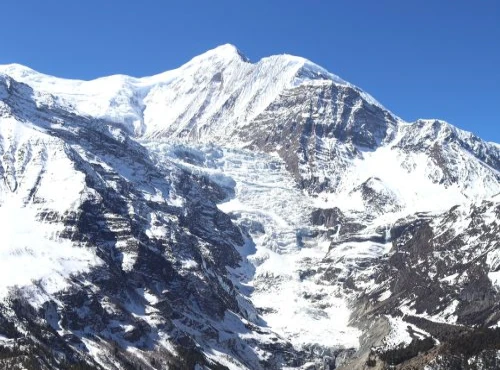
You will reach a valley if you follow the Rolwaling River up. From there, you can view the Gaurishankar peak (7,134 meters). The trek's days will grow shorter as you approach higher elevations, but the path will begin to level off again.

Make sure to practice with your equipment and brush up on your abilities before heading to Ramdung Base Camp (5,040m). Before setting up camp there at night, visit the Ramdung Glacier and the Ramdung High Camp. Then, early in the morning, they ascend. You cannot linger at the peak for too long because it is located at 5,925 meters. However, before returning to base camp, you will have time to enjoy the breathtaking views.

Travel Insurance for Climbing Ramdung Peak

All clients who wish to hike or climb with us must have travel insurance. The insurance should cover you in the event of accidents, altitude sickness, and, if necessary, costs associated with ambulance and helicopter rescue. While traveling in Nepal, kindly bring a copy of your insurance documents and give us a copy. This will enable us to make the essential preparations in an emergency. 

Altitude sickness on Climbing Ramdung Peak

Even the most athletic trekkers are susceptible to the insidious monster known as altitude sickness. This necessitates making every effort to get ready for high-altitude trekking and being cautious the entire time. High altitude sickness is caused mainly by a reduction in the amount of oxygen that is readily accessible as you ascend in height.

Ramdung Peak climbing requires good acclimatization because it is a high-altitude hike. Start at a lower altitude and gradually work your way up since your body needs time to become used to the thin air. The following are a few signs of altitude sickness:

  • Initial symptoms of altitude sickness
  • include expanded breathing
  • and a rise in urination.
  • Headache and sleep disturbance.
  • Breathing in and out periodically during the night.
  • Dehydration.

Effects of Having Altitude sickness

  • respiration difficulty.
  • Extreme exhaustion, respiratory malfunction
  • brain swelling.
  • Coma.

To prevent the problem from getting worse, several precautions should be taken. First, however, you might need to descend to a lower height and get medical attention if the symptoms worsen. However, you can take several additional measures to reduce your risk of altitude sickness when hiking.

Because it takes time for our systems to acclimate to the increased oxygen level, trekkers can alter their bodies by rising gently and steadily. High altitude hiking necessitates at least one day of acclimatization rest, and you should ascend to the highest point before descending to a lower altitude for the night. Because it takes time for our systems to acclimate to the increased oxygen level, trekkers can alter their bodies by rising gently and steadily. High altitude hiking necessitates at least one day of acclimatization rest, and you should ascend to the highest point before descending to a lower altitude for the night.

To build strength and endurance for your expedition, you should engage in various strength training exercises, including running, cycling, jogging, push-ups, and visiting the gym. Elevation decreases oxygen levels as the air becomes increasingly thin, and in the Rolwaling area, height also means fewer flowers. In addition, the amount of water in the body is reduced by tobacco, alcohol, and cigarettes.

Accommodations and Food on Climbing Ramdung Peak

For climbers, food is the most crucial energy source during their ascent and expedition. To replenish your energy hourly, include emergency health energy bars and dry meals.

You won't be able to explore all of the world's unique natural attractions in a single trip; instead, you must choose according to what appeals to your senses the most. There will always be a more picturesque location in the Himalayas, no matter where you travel. Additionally, a comfortable hotel is a crucial component of the voyage because it aids in your body's preparation for the walk the following day. A good night's sleep and enough rest are essential in high-altitude climbs.

You may choose between staying in lodges, guesthouses, or tents when climbing Ramdung Peak. However, it's a good idea to pack a sleeping bag to ensure a cozy and warm night's sleep.

The Internet and electricity are available in the Rolwaling region

Electricity source

One of Nepal's most isolated regions is the Rolwaling Valley. Electricity is not accessible. Solar energy is the sole source of electricity used in the entire valley and can only light one bulb. There isn't a power outlet in your room. So your gadget won't be able to charge using solar power, even if you are prepared to pay for charging. Our walk begins and ends in Chetchet, where you may charge your electronic devices. It is advised that you pack a power bank that will last the whole walk. A new hydropower project has recently been planned near the Rolwaling valley, and a power pole has been set up. Rolwaling valley will therefore have access to energy in a few years.

Internet service and facilities

To stay in touch with your loved ones, colleagues, and coworkers, publish updates on your journey and upload images, you'll need access to the Internet and a network facility. Unfortunately, because there is no power, there is no internet service in Rolwaling Valley.

Until Tsho Rolpa, NTC Cellular has been offering GSM mobile network service in the Rolwalin valley. The NTC sim card costs $1 and is available at retailers in Kathmandu. You may access the Internet from NTC to Tsho Rolpa by purchasing data packages, but only when the mobile network receives a signal.

Arrangements for Staff and Guide

Our skilled and knowledgeable team will manage all your activities throughout the walk. In addition, they will conduct the entire escort. In addition, we will supply you with a highly qualified and experienced guide who speaks fluent English, has good navigational abilities, and has rope-fixing skills because this is one of the trickiest and hardest treks. They will travel with you from Kathmandu and serve as your guides while you ascend Ramdung Peak.

Our lead guides, assistant guides, and potters are all highly qualified and knowledgeable. We thus ask for your cooperation and respect for them during the journey.

Smart Travel Rolwaling Valley

The undiscovered tourist spot in Nepal is the Rolwaling Valley. The most remote and culturally rich settlement in the Rolwaling valley. You will get to observe the customs of this region's long-established Chettri, Gurung, and Sherpa populations. The least populated valley is the one in question.

Therefore, you must respect the locals, their local customs and culture, as well as the environment and the natural world. By utilizing local goods and services, you may assist them. You can learn some polite Nepali phrases, such as "Namaskar" and "Tashi Delek," which indicate "good day," "good luck," and blessings.

You have to keep your cool while you stroll down the woodland route. Play no music in the forest. It alarmed the animals. We anticipate that you will responsibly dispose of your plastic waste (food wrappers and plastic water bottles). You must receive permission from the Nepalese government to hike through Rolwaling Valley because it is a restricted region. The infrastructure in this valley is not very advanced because it is a recently discovered trekking location. Your minor acts of disrespect and carelessness might have serious consequences down the road. Your ethical travel will aid Nepal in developing a long-term, sustainable tourist industry.

Details about Nepal's tourist visas and permits.

You must have a tourist visa that is valid for the whole length of your intended stay in Nepal in order to travel there. It is preferable if you have a tourist visa that is good for at least one month because anything may happen while you are traveling, and if you stay in Nepal after your Visa expires, you will be fined. Apply for a visa at the Nepali embassy that is most convenient for you, or pick one up at immigration at Kathmandu's Tribhuvan International Airport. Contacting the Nepalese Embassy nearest you is preferable.

These are the documents you'll need to submit with your visa application.

  • The Nepal Tourist Visa Application Form (fully completed online and printed)
  • Original passport, valid for at least six months, with at least two blank pages.
  • Copy of the information page from your passport. 
  • At least two recent, white-background passport-sized pictures of yourself.
  • Evidence of lodging in Nepal.
  • Travel and return tickets that are valid.
  • A recent three-month bank statement with a minimum closing amount of NPR 2,000,000.
  • Receipt of the Nepal visa fee.


Backpack essentials for climbing Ramdung Peak

A traveler's luggage might also give away how experienced they are. A fantastic trekker needs to be a savvy traveler. You should be ready for the items you'll need on the voyage. It would help if you packed adequate provisions for the walk because it is in a rural valley, and there are no stores once you leave the road.

A list of all the clothes and equipment

  • HEADWEAR
  1. Wear a brimmed hat or a sun cap on your head.
  2. Headscarf
  3. Hat with warm knit
  4. Buff/Neck Gaiter, or Balaclava
  5. Headlamps
  6. Google or sunglasses


  • INNER BODYWEAR:- Underwear
  • The Foundation Layer: fleece woolen shirt or fleece woolen pants
  • The middle layer: shirts, thermal shirts, fleece pants, fabric shirts, thermal trousers
  • OUTER LAYER: Jacket with hood or water-proof jacket
  • HANDWEAR AND FOOTWEAR: hiking gloves, hiking shoes, hiking boots, etc 
  • Travel equipment: duffel bags, sleeping bags, poles for trekking,  
  • MEDICATIONS: first aid medicines and daily use medications  


Climbing Ramdung Peak in Spring: March, April, May

The greatest time to travel to the Nepalese Himalayas is during the spring months of March through May. During these months, the temperature is warmer, and the sky and weather are pretty straightforward and sunny. Temperatures of 20 to 25 degrees are typical at under 3,500 meters. However, they will decrease at night. Once over 3,500 feet, you may anticipate dramatic temperature reductions at night and early morning, frequently as low as -15 degrees.

In these months, there is a little bit of rain, but nothing too heavy, and this helps to bring out the natural colors in the diverse flora and fauna, notably in the rhododendron, the national flower of Nepal.

June to August are the months of summer

The monsoon season in Nepal occurs in June, July, and August, although it occasionally lasts into mid-September. Mid-June, before the rains get up, is a good time for specific hikes, but visibility may be poor.

The rains bring additional difficulties and barriers. Mountain flights don't happen too often.

While landslides may prevent access to roadways, while it is still feasible to go hiking in the middle of June, we advise against classic climbs like Everest because the possibility of protracted delays at Lukla might result in missing an international flight.

Climbing Ramdung Peak in Autumn:- September, October, and November is the season of fall.

The fall season goes from mid-September to mid-December and has weather somewhat comparable to spring. It is also the best time to go climbing. There are several hiking choices available because there is a large window of good vision.

The Dashain/Tihar/Chhat festivals and other celebrations are particularly well-known at this time of year. In addition, long national holidays make it possible for many individuals to visit family in their villages, increasing the vibrancy of rural Nepal. Generally, bright skies, little rain, and mild temperatures are the norm.

FAQs

  • Q1. Is it possible to pay a porter to carry my backpacks?

    The answer is that you may pay a personal porter to carry your bags on the adventure. But hiring a porter can come at an additional expense.


  • The adaptations will be substantial if you are not accustomed to living at a high altitude. However, if you proceed slowly and cautiously, altitude sickness can be avoided.

  • Ramdung Peak may be difficult to climb, especially if you are not accustomed to being at high elevations. Before attempting to summit, it is crucial to take your time and acclimate to the altitude. Although the climb itself is not particularly technical, there are a few steep stretches that can be difficult.

Client Reviews

  • Mixed of expereince

    We are a group of 6 heading to Ramdung peak. We did a trek with owner Dipak Pande. He is an honest and service printed guy, we choose his company and it was well arranged in this remote of Nepal. thank you our kitchen staff, guide, and sherpas. Most recommended company in Nepal for trekking and tour.

    T
    TrentSwitzerlandJuly 03, 2022
dipak pande
Need Any Assistance?

Our team has extensive knowledge and experience of the Himalayas and can design your dream Trip based on your Expectation, location, time frame, and Budget.

Call us on WhatsApp +977 9851037679 (Dipak Pande)

Similar Trips

Ask a Question