Why We Need EBC Trek and Return by Helicopter Map?
Our Everest Base Camp Trek and Return by Helicopter Map is a simplified map in the form of JPEG images, totally different from the complex map you find online. This does mean the map we generally see on the internet is bad information providers. In fact, they provide the most detailed information about the wholeEverest region. Still, those maps are tough to read, which leads to failure to find the route you want to travel in the Everest region.
Therefore, we present our Everest Base Camp Trek and Return by Helicopter Map and itineraryfor your convenience. Carrying our map and itinerary is necessary to get information about the elevation data, samples representing mountains, temples, etc. Likewise, if you get lost, our map and itinerary to help you find your way out if you get lost while trekking.
Our guide and porters, experienced hikers, and map readers will be there for you the whole time. Still, carrying a map and itinerary with you will not hurt anyone as there is enough information on our Everest base camp trek map and itinerary to plan every region trip in advance.
Backpackers find the Everest Base camp trek with helicopter return maps highly advantageous. Unlike other maps, it provides a comprehensive representation of the terrain you travel, including driving routes, elevations, landmarks, resting places, and numerous details.
Individuals can observe on a two-dimensional map using our map and itinerary details. Proficient readers of these maps can discern the precise elevation and position of valleys, peaks, ridges, and various land features. Additionally, our map and itinerary of the Everest region can indicate whether a chosen travel route will involve ascending, descending, or traversing a level trail or path.
Everest Base Camp Trek and Helicopter Return Experience With Map
If you want to know about the Everest Base Camp Trek and Helicopter Return Experience With a Map and itinerary, this is the place for you. With this information, you will find all the required information about the train in every detail here.
Everest base camp trek with an added feature of helicopter return is a more fabulous feeling than doing a regular EBC trek without any benefit.
Undoubtedly, the trek to Everest Base Camp helicopter return with our map and itinerary proves to be a coveted experience for adventurers worldwide compared to those without a map—the conventional approach is generally a 14 to 16-day expedition, covering a considerable distance of approximately 130 kilometers. However, alternative itineraries like this one offer shorter durations for the trek, where you can complete the trek within 10 days.
Our Everest Base Camp trek with a helicopter return map and itinerary allows you to trek to Everest Base Camp and conveniently return by helicopter from the Kala Patthar viewpoint. Following this plan, you would only need to trek 65 km out of 130 km, as the helicopter ride covers the remaining portion.
Including a helicopter tour (return) in the Everest Base Camp trek offers several advantages. Firstly, it saves significant time that would have been spent on the return trek, thereby conserving energy. This particular trek is known for its challenges, and adding a helicopter makes it somewhat easier. Opting for this itinerary reduces the expedition's difficulties by a significant margin, making it stand out from other options.
The best part of the Everest Base Camp trek with a helicopter return with our map and itinerary is that you get to experience it all and imagine it all even before the start of the trek. Not only will you trek and explore the magnificent Everest Region, but you will also enjoy a breathtaking bird's-eye view of the area. You will witness traditional settlements like Tengboche, Namche Bazaar, and Phakding by passing through them and flying over them.
Moreover, you will be able to witness the abundant vegetation of the Sagarmatha National Park. This trek ensures that no aspect of the Everest experience is left unexplored. In a nutshell, you will have the chance to immerse yourself in all the wonders Everest offers.
And the best part is that you can enjoy all of this without completing the full circular trail. Simply trek to Everest Base Camp, experience the trek in the Everest region firsthand, and then take a scenic flight back to where it all began.

Everest Base Camp Trek and Helicopter Return Route Map
Our Everest base camp trek is an exciting and luxurious way to visit the Everest base camp trek and return. As indicated by our ma, your official treks start from Kathmandu and take you directly toward the base camp, which is generally 53 km (33 miles) far. However, this is just a rough figure estimated by our map. In fact, you will be trekking around 65 km (40 miles) in total if you altogether count the round trips day during your acclimatization day at Namche bazaar and send to kala patthar, known as 'Black Rock, for the up-close view of Mount Everest (tallest peak of the world).
Climbing Mt Everest is indeed a great feat, but even if you make it up to its base camp, this would be a massive achievement. As indicated by our map, your official journey starts with a short flight to Lukla, continuing your trek towards Phading, Namche Bazaar, from Lukla. You will spend the night in Namche Bazar and continue to trek towards Tengboche Dingboche, Lobuche, Gorak Shep, Everest base camp, and Kala Patthar.
During your trek, you will encounter numerous captivating trails once traversed by the pioneers of Everest, leading you through dense forests, traditional Sherpa villages, and serene green landscapes. Deep canyons and swiftly flowing rivers will accompany you as you journey, contrasting with the frigid and desolate terrain at the base of the majestic mountain peaks. This exhilarating adventure also allows you to explore the Nepalese people's rustic mountain lifestyle.
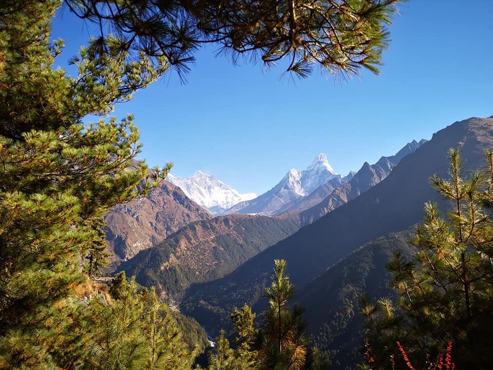
You will return via a thrilling helicopter ride after completing your trek to Everest Base Camp. From the vantage point of the helicopter, you will behold a panoramic view of the shimmering mountain summits, including the renowned Mt. Everest (8848 m), Mt. Lhotse (8516 m), Mt. Nuptse (7855 m), Mt. Pumori (7161 m), Mt. Changaste (7550 m), Mt. Ling-erie (6679 m), Mt. Amadablam (6856 m), Mt. Thamserku (6723 m), Mt. Kongde (6011 m), Mt. Twache Peak (6367 m), Mt. Cholaste (6335 m), Island Peak (6179 m), Lobuche Peak (6145 m), Pokalde Peak (5806 m), and Honku South Peak (6119 m). These towering peaks are the prominent highlights of the region during your helicopter return to Kathmandu.
Everest Base Camp Trek and Helicopter Return Map Details or Explanation
Our updated Everest base camp trek and heli return map and itinerary is an updated and high-quality trek map. Therefore you will get accurate information about the routes you will be taking with an alternative option to choose from up to the Mt. Everest base camp. There are several trekking routes to choose from, from Kathmandu to Everest. For example, you can select the route from Kathmandu to Jiri and Lukla or from Kathmandu to Phaplu and Lukla to Everest Base Camp.
This Everest base camp trek map clearly illustrates the trails you will be taking, highlighting the landmarks you will encounter while trekking to the base camp. Likewise, our map outlines the steep rocky ascends, notable landmarks, and gently sloping valleys while trekking in the Everest region.
In addition, the map also represents the distance measurements to include the highest elevation points we will reach during the ascending trek.
Our well-designed Everest base camp trek with heli return map is ideal for backpackers of all kinds as it showcases the Everest area's particular features and terrain. Also, as you look closely, you will see many symbols representing various features, such as rivers, mountains, landmarks, stupas, temples, avalanches, areas, etc. This information on our map helps the trekkers remember everything, like the important landmarks during the trek. Likewise, the colored trekking routes with additional detail will not let you get lost on the trek.
We have added an extra feature on our map where you can even look closer by zooming in with the help of your mouse. Also, the red dotted line indicates the main trekking routes of the trek. And the driving route represented a red-bordered blue line. At the same time, the single dotted blue line showcases the secondary route you can travel in the Everest region. The mountain symbols on our map are the famous peaks you will encounter during the trek, like Mt Everest, Ama Dablam, Mera Peak, Island Peak, Lhotse, Pumori, etc. Our map also represents the avalanche risk area, shown by the white mountain figure encircled in the blue circle. In addition to all these figures, you can see the helicopter symbol representing the helicopter journey we will be taking back after completing our Everest base camp trek on the 10th day.
An extra altitude map is attached to the trekking map, which is suitable for trekkers who want to know how much altitude they will gain during their trek.
Everest Base Camp Trek with Helicopter Return Outline Itinerary
With an additional map, we also provide a comprehensive itinerary for hiking in the Everest region. Your starting point of the trek will be Lukla, and to get there, you will board a 45 minutes flight first. So there is a possibility of flight cancellation and delayed flights. And you will be staying in the teahouses for accommodation.
Day 01: Fly from Kathmandu to Lukla and Trek to Phakding
- Kathmandu Elevation- (1,400m / 4,593ft)
- Lukla Elevation- (2,850m / 9,350ft)
- Flight- Kathmandu to Lukla Airport (45- 60 min)
- Trekking started- Town of Lukla (2,860 m / 9,383 ft)
- Trek total distance- 8.2 km / 5.1 mi
- Trek duration- 3-5 hours
- Overnight- Teahouse of Phakding
Day 02: Trek from Phakding to Namche Bazaar
- Namche Bazaar Elevation- (3,440 m / 11,286 ft)
- Trek total distance- 9.4 km / 5.6 mi
- Trekking Duration- 5-6 hours
- Overnight- Tea House at Namche Bazaar
Day 03: Acclimatization Day in Namche Bazaar
- Overnight- Namche Bazaar (3,440 m / 11,286 ft)
- Accommodation- Same teahouse as day 2
Day 04: Trek from Namche to Tengboche
- Tengboche Elevation- (3,870 m / 12,696 ft)
- Trekking Started- Namche Bazaar (3,440 m / 11,286 ft)
- Total Trek distance- 9.6 km / 6 mi
- Trekking Duration- 5- 6 hours
- Overnight- Tea House at Tengboche
Day 05: Trek from Tengboche to Dingboche
- Dingboche Elevation- (4,360 m / 14,304 ft)
- Trekking Started- Tengboche (3,870 m / 12,696 ft)
- Total Trek distance- 10.5 km / 6.5 mi
- Trekking Duration- 6- 7 hours
- Overnight- Tea House at Dingboche
Day 06: Acclimatization Day in Dingboche
Day 07: Trek from Dingboche to Lobuche
- Lobuche Elevation- (4,940 m / 16,207 ft)
- Trekking started- Dingboche (4,360 m / 14,304 ft)
- Total Trek distance- 8.4 km / 5.2 mi
- Trekking Duration- 5 hours
- Overnight- Teahouse at Lobuche
Day 08: Trek to Gorak Shep and hike to Everest Base Camp, and return to Gorak Shep
- Gorak Shep Elevation- (5,164 m / 16,942 ft)
- Trekking Started- Lobuche (4,940 m / 16,210 ft)
- TTrek distance- 10.8 km / 6.7 mi
- Trekking Duration- 4 hours +4 Hours
- Everest Base Camp elevation- 5,364 m / 17,598 ft
- Overnight- Gorakshep Tea Houses
Day 09: Trek to Kala Patthar and Fly to Lukla Via Helicopter to Kathmandu
- Trekking Started- Gorakshep (5,164 m / 16,942 ft)
- Kala Patthar elevation- 5,545 m (18,514 ft)
- Total Trek distance- 3.2 km / 1.9 mi
- Trekking Duration- 3 hours
- Helicopter flight- Gorak Shep to Kathmandu (70 Minutes)
Day 01: Fly from Kathmandu to Lukla and Trek to Phakding
As the map indicates, our Everest base camp trek with heli return starts from Kathmandu with a 45 minutes flight to Lukla. Lukla generally holds two titles, one being the most dangerous airport in the world and another being the gateway for treks like Everest base camp and the Everest climbing expedition itself. This flight from Kathmandu to Lukla is probably the most unpredictable part of our Everest base camp trek with a heli return itinerary and map, as the flight has frequent cancellations and delays.
After landing in Lukla, we started our official trekking toward the speaking village, as indicated by our map above. To reach here, we first pass the Chaurikharka village and quickly descend towards the Dudhkoshi Ghat (2,530m / 8,300ft). The trek today up to Phakding will be short and enjoyable, with proper acclimatization. During our time in Phakding, we will visit a few places like Rimishung Monastery.

Day 02: Trek from Phakding to Namche Bazaar
Today will be a longer hike than yesterday, but the hike will not have very few places to rest. This being said, here is just a place 1 Km away to rest while trekking, so it's essential to carry water and snacks for your hunger and hydration. For this trek, do not walk fast and make a few stops along the way; this will help to prevent AMS.
From Here, we will travel along the Dudh Koshi River while enjoying the peak views and crossing many suspension bridges, including the famous Hillary Suspension Bridge.
We continue to trek further and arrive at Sagarmatha National Park's check post, where you will register your permits. Moreover, after passing through these forests, we will catch the first view of the highest mountain in the world- Mt Everest. We will continue to trek further and finally arrive at Namche Bazaar- also called the Sherpas town and the gateway to Everest. Overnight will be at one of the tea houses of Namche Bazaar.

Day 03: Acclimatization Day in Namche Bazaar
Acclimatization during all high-altitude trekking, including the Everest base camp trek, is a must even if you feel fine during your trek.
During your acclimatization/ rest day, you can either sit at your respective tools, take a full rest, or you could go on a day hike around the Namche bazaar, also known as the acclimatization hike. Namche Bazar is a well-established area, meaning you will get plenty of coffee shops and bakeries here to try out sherpa tee and coffee prepared by the locals.
The most popular acclimatization hike is a short hike to Hotel Everest View, just above the Namche bazaar, and requires around a 1-hour hike to reach there. Everest View Hotel is known as the first hotel in the world to be built at the highest elevated height, so you probably do not want to miss this short hike. Besides the Everest view hotel, you can visit Sagarmatha National Park Museum, which requires a mere 20 minutes hike from Namche Bazaar.
Day 04: Trek from Namche to Tengboche
Today we will trek from Namche Bazaar and head towards Tengboche. For this, we will trek through the route full of ups and downs. Also, we will trek through the forests, tackling all the challenges along the way and enjoying the views of the peak rising above 7000m and 8000 m. f you are lucky, you can also enjoy the sight of rare animals like musk deer, pheasants, Himalayan Tahrs, etc.
We continue to trek forwards and reach Phunki Tenga Village. From Phunki Thenga Village, you will ascend further, leading you directly toward the Tengboche. Tengboche is a beautiful place characterized by its natural beauty, which opens up to famous peak views like Lhotse, Everest Ama Dablam, and Lhotse. In addition to the mountain views, you also get to visit the Tengboche monastery, which is the largest monastery in the Khumbu Region. Overnight will be at one of the tea houses of Tengboche.

An alternative option is also available if you do not want to trek all the way up to Tengboche. This option is best for those trekkers who are not feeling great due to headaches, tiredness, nausea, etc. For this alternative option, you can stop along the way to Tengboche, e.g., in Phudgi Thangaa, and then continue the trek.
Day 05: Trek from Tengboche to Dingboche
The Everest Base Camp trek with a heli return itinerary is bound to pose another challenging day. As you ascend beyond 4000m, the high altitude takes its toll, leaving you fatigued. Even a slight uphill climb leaves you breathless. Once breakfast is over, our next destination will be Dingboche. We will encounter numerous Chortens, mani walls, and quaint villages along the way. Among them is Pangboche, offering breathtaking views of Mt. Ama Dablam. Throughout the trek, you will ascend altitude, and as you approach Dingboche, you will notice fields encircled by stone walls, serving as protection for the crops. Despite the harsh conditions, the locals successfully cultivate barley, buckwheat, and potatoes.

Day 06: Acclimatization Day in Dingboche
After completing a strenuous ascent of over 500m in a single day, we will again add a rest day/acclimatization day off in Diingbohe. Even though we do not experience any Acute Mountain Sickness (AMS) symptoms, you still need to exercise caution and rest extra before heading to EBC.
Some individuals, too, opt for acclimatization hikes from Dingboche to nearby peaks. During your short hike, you can hike around, visit the stupas atop the hills, and spend the remainder of the day in the dining rooms, indulging in tea and relaxation.
However, to keep yourself occupied, you can plan to walk up the ridge above Dingboche to witness the awe-inspiring vistas of mountains such as Ama Dablam, Island Peak, Cho Oyu, and Makalu.
Day 07: Trek from Dingboche to Lobuche
The trek to Lobuche begins on this trail, which is a bit near the ridge above Pheriche Village. As you keep going, you'll find yourself walking next to the Khumbu Glacier, going higher up to the Thukla Hills. At the Thukla Hills, you'll see these statues honoring climbers who didn't make it in this area.
And then, we keep on trekking until we reach Lobuche, where we're heading for the day. The walk was stunning, like the best day ever on the Everest Base Camp trek. There's only this one spot to take relaxation between Dingboche and Lobuche called Dughla. You can stop at Dughla for tea and then continue your trek further.

Day 08: Trek to Gorak Shep and hike to Everest Base Camp, and return to Gorak Shep
Today's trek is exceptional as we are about to reach Base Camp, marking a remarkable milestone. Our journey begins by crossing the sideways moraine of the Khumbu Glacier, leading us to the picturesque Gorak Shep Village, nestled amidst majestic snow-capped mountains.
Leaving our belongings behind in Gorakh Shep, we hike to Base Camp, providing the closest vantage point to the world's highest peak. The breathtaking views from EBC offer a feast for the eyes, allowing us to capture the surroundings in photographs and reflect upon cherished memories and accomplishments before retracing our steps back to Gorak Shep. En route, we also will encounter the Khumbu Glacier.

To make the most of our day, we must start our trek early and reach Gorak Shep before midday. This timing allows enough opportunity to visit Everest Base Camp and return before nightfall, as daylight hours lessen. Overnight will be at one of the tea houses of Gorakh Shep.
Day 09: Trek to Kala Patthar and Fly to Lukla Via Helicopter to Kathmandu
We will wake up early at Gorak Shep and hike to Kala Patthar. We aim to witness the breathtaking sunrise over Mt. Everest and the surrounding peaks. The sight of the morning sunlight surrounding Mt. Everest is unparalleled. You can leave your belongings at the hotel and take only a day hiking pack.

Once we have taken some time in the magnificent view, we will return to Gorak Shep. As the tour draws closer, a helicopter will be ready for our flight. The helicopter flight from Gorekshep to Kathmandu is approximately 70 minutes in good weather, excluding ground handling time. You can witness the Everest Region from a bird's-eye perspective during the flight. This marks the completion of the Everest Base Camp Trek, and you'll return by helicopter.


